Back Propinsi Naryn ACE مقاطعة نارين Arabic نارين اوبلاستى ARZ Narin vilayəti Azerbaijani Нарынская вобласць Byelorussian Нарынская вобласьць BE-X-OLD Наринска област Bulgarian Província de Narín Catalan Нарынан область CE Naryn oblast CEB
Naryn Region
| |
|---|---|
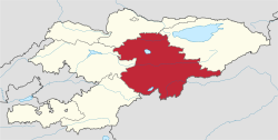
 Map of Kyrgyzstan, location of Naryn Region highlighted | |
| Coordinates: 41°30′N 75°30′E / 41.500°N 75.500°E | |
| Country | |
| Capital | Naryn |
| Government | |
| • Gubernator | Omurbek Suvanaliev |
| Area | |
| • Total | 44,160 km2 (17,050 sq mi) |
| Population (2023-01-01)[1] | |
| • Total | 308,348 |
| • Density | 7.0/km2 (18/sq mi) |
| Time zone | UTC+6 (KGT) |
| ISO 3166 code | KG-N |
| Districts | 5 |
| Cities | 1 |
| Villages | 134 |
| HDI (2021) | 0.674 [2] medium · 5th |
Naryn Region (Kyrgyz: Нарын облусу, romanized: Naryn oblusu; Russian: Нарынская область, romanized: Narynskaya oblast) is the largest region (oblus) of Kyrgyzstan. It is located in the east of the country and borders with Chüy Region in the north, Issyk-Kul Region in the northeast, Xinjiang Uyghur Autonomous Region of China in the southeast, Osh Region in the southwest, and Jalal-Abad Region in the west. Its capital is Naryn. Its total area is 44,160 km2 (17,050 sq mi).[3] The resident population of the region was 292,140 as of January 2021.[1]
The main highway runs from the Chinese border at Torugart Pass north to Balykchy on Issyk-Kul Lake. It is known as the location of Song Köl Lake and Chatyr-Kul Lake and Tash Rabat.
The population of Naryn oblast is 99% Kyrgyz. The economy is dominated by animal herding (sheep, horses, yaks), with wool and meat as the main products. Mining of various minerals developed during the Soviet era has largely been abandoned as uneconomical.[4] It boasts mountains, alpine pastures, and Song Köl Lake which during summer months attracts large herds of sheep and horses with their herders and yurts.
- ^ a b "Population of regions, districts, towns, urban-type settlements, rural communities and villages of Kyrgyz Republic" (XLS) (in Russian). National Statistics Committee of the Kyrgyz Republic. 2021. Archived from the original on 10 November 2021.
- ^ "Sub-national HDI – Area Database". hdi.globaldatalab.org. Global Data Lab.
- ^ "2009 population and housing census of the Kyrgyz Republic: Naryn Region" (PDF) (in Russian). National Statistics Committee of the Kyrgyz Republic. 2010. pp. 12, 15, 39, 145.
- ^ Sternberg, Troy (2020). "Conflict and contestation in Kyrgyz mining infrastructure". The Extractive Industries and Society. 7 (4): 1392–1400. doi:10.1016/j.exis.2020.10.016. S2CID 229423618.
© MMXXIII Rich X Search. We shall prevail. All rights reserved. Rich X Search


