Back Nəsirabad rayonu Azerbaijani নাসিরাবাদ জেলা Bengali/Bangla Nasīrābād District CEB Nasirabad (Distrikt) German ناحیه نصیرآباد Persian District de Nasirabad French Nasirabad Hausa नसीराबाद जिला Hindi Distretto di Naseerabad Italian Dystrykt Nasirabad Polish
Naseerabad District
ضلع نصیر آباد | |
|---|---|
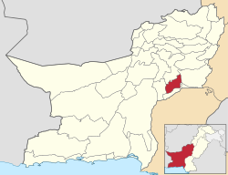
 Map of Balochistan with Nasirabad District highlighted | |
| Country | |
| Province | |
| Division | Nasirabad |
| Headquarters | Dera Murad Jamali |
| Government | |
| • Type | District Administration |
| • Deputy Commissioner | Muhammad Qasim |
| • District Police Officer | N/A |
| • District Health Officer | N/A |
| Area | |
| • Total | 3,387 km2 (1,308 sq mi) |
| Population (2017)[1] | |
| • Total | 487,847 |
| • Density | 140/km2 (370/sq mi) |
| Time zone | UTC+5 (PST) |
Nasirabad (Urdu: ضلع نصیر آباد) is a district in the centre-west of Balochistan, Pakistan. The district's headquarters are located at Dera Murad Jamali.
The original name of the district was Temple Dera, named after Captain H. M. Temple,[citation needed] a career British civil servant, who served as the Political Agent for Sibi from 1891 to 1892. Among the local population it is still known as 'Tipul', a corruption of the word 'temple'.[citation needed]
Formerly part of Kalat District, Nasirabad was granted the status of a separate district in 1974, while in 1987 the new district of Jaffarabad was cleaved out of it.[2] For three years, from July 1987 to December 1990, it was known as Tahseel Tamboo. Tamboo is a small village 40 km west of Dera Murad Jamali.[citation needed]
© MMXXIII Rich X Search. We shall prevail. All rights reserved. Rich X Search