Back ناتولا Arabic নাথু-লা গিৰিপথ Assamese नाथु ला Bihari নাথু লা গিরিপথ Bengali/Bangla Natu La CEB Nathu La Welsh Nathu La Danish Nathu La German Nathula Esperanto Nathu La Spanish
| Nathu La | |
|---|---|
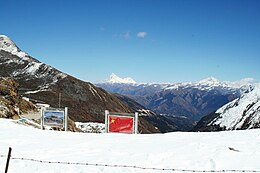
Chumbi Valley visible from the Indian side (center). The main gate between the two sides (bottom). The stone walls were constructed in a build-up to the 2006 reopening.[1] | |
| Elevation | 4,310 m (14,140 ft)[2][3] |
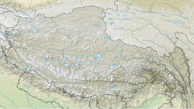
| Location | Sikkim, India – Tibet, China |
| Range | Dongkya Range, Himalaya |
| Coordinates | 27°23′13″N 88°49′51″E / 27.38681°N 88.83095°E |
| Nathu La |
|---|
Nathu La[a](Tibetan: རྣ་ཐོས་ལ་, Wylie: Rna thos la, THL: Na tö la, Sikkimese: རྣ་ཐོས་ལ་) is a mountain pass in the Dongkya Range of the Himalayas between China's Yadong County in Tibet, and the Indian states of Sikkim. But minor touch of Bengal in South Asia. The pass, at 4,310 m (14,140 ft), connects the towns of Kalimpong and Gangtok to the villages and towns of the lower Chumbi Valley.
The pass was surveyed by J. W. Edgar in 1873, who described the pass as being used for trade by Tibetans. Francis Younghusband used the pass in 1903–04, as did a diplomatic British delegation to Lhasa in 1936–37, and Ernst Schäfer in 1938–39. In the 1950s, trade in the Kingdom of Sikkim used this pass. Diplomatically sealed by China and India after the 1962 Sino-Indian War, the pass saw skirmishes between the two countries in coming years, including the clashes in 1967 which resulted in fatalities on both sides. Nathu La has often been compared to Jelep La, a mountain pass situated at a distance of 3 miles (4.8 km).
The next few decades saw an improvement in ties leading to the re-opening of Nathu La in 2006. The opening of the pass provides an alternative route to the pilgrimage of Mount Kailash and Lake Manasarovar, and was expected to bolster the economy of the region by playing a key role in the growing Sino-Indian trade. However, while trade has had a net positive impact, it under-performed,[13] and is limited to specific types of goods and to specific days of the week. Weather conditions including heavy snowfall restricts border trade to around 7 to 8 months.
Roads to the pass have been improved on both sides. Rail routes have been brought closer. It is part of the domestic tourist circuit in south-east Sikkim. Soldiers from both sides posted at Nathu La are among the closest along the entire Sino-India border. It is also one of the five Border Personnel Meeting points between the two armies of both countries. 2020 border tensions and the coronavirus pandemic have affected tourism and movement across the pass.
- ^ Cite error: The named reference
Friendshipwas invoked but never defined (see the help page). - ^ Cite error: The named reference
OSMwas invoked but never defined (see the help page). - ^ ENVIS Centre on Eco-Tourism, Sikkim (2006), p. 32.
- ^ Harris 2013, p. ix.
- ^ Gokhale, Nitin A. (3 October 2003). "Hallelujah, Nathula!". Outlook India.
- ^ India, Sikkim, United States, Central Intelligence Agency, 1981.
- ^ Shakabpa, Tsepon Wangchuk Deden (2009), One Hundred Thousand Moons: An Advanced Political History of Tibet, Brill, p. 643, ISBN 978-90-04-17732-1
- ^ Sessional papers. Inventory control record 1, Volume 67, Great Britain, Parliament, House of Commons, 1904, p. 28: "Yatung is situated about eight miles from the Jeylap-la in the valley of the Yatung Chhu at its junction with the Chamdi Chhu which runs down from Natoi-la."
- ^ Smith 1913, pp. 325–327.
- ^ Edgar 1874, pp. 53, 57, 121.
- ^ "Opening of new pilgrimage route in Tibet by China makes it easier for Indian pilgrims" (PDF), Jiefang Daily, 29 October 2015 – via India in the Chinese Media (niasindiainchina.in)
- ^ Balazs 2021, p. 149.
- ^ Economic under performance
Cite error: There are <ref group=lower-alpha> tags or {{efn}} templates on this page, but the references will not show without a {{reflist|group=lower-alpha}} template or {{notelist}} template (see the help page).
© MMXXIII Rich X Search. We shall prevail. All rights reserved. Rich X Search


