Back Neris Afrikaans نيريس Arabic نهر نيريس ARZ Neris (kuksa) AVK Neris çayı Azerbaijani نریس چایی AZB Nerės BAT-SMG Вілія Byelorussian Вяльля BE-X-OLD Вилия (река) Bulgarian
| Neris | |
|---|---|
 | |
 | |
| Location | |
| Country | Belarus, Lithuania |
| Physical characteristics | |
| Source | |
| • location | Belarus |
| Mouth | Neman |
• coordinates | 54°54′01″N 23°52′27″E / 54.90028°N 23.87417°E |
| Length | 510 km (320 mi) |
| Basin size | 24,942.3 km2 (9,630.3 sq mi) |
| Discharge | |
| • average | 182 m3/s (6,400 cu ft/s) |
| Basin features | |
| Progression | Neman→ Baltic Sea |
| Tributaries | |
| • left | Oksna |


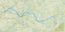
The river Neris () or Vilija (Belarusian: Ві́лія, romanized: Vilija, Polish: Wilia) rises in northern Belarus. It flows westward, passing through Vilnius (Lithuania's capital) and in the south-centre of that country it flows into the Nemunas (Neman) from the right bank, at Kaunas, as its main tributary. Its length is 510 km (320 mi).
After passing through Belarus for 276 km (171 mi),[1] the Neris flows through Lithuania for a further 235 km (146 mi).
The Neris connects successive Lithuanian capitals – Kernavė and Vilnius. Along its banks are the burial places of the pagan Lithuanians. At 25 km (16 mi) from Vilnius there is are old Karmazinai Hillfort and Karmazinai burial mound.
- ^ "Main Geographic Characteristics of the Republic of Belarus. Main characteristics of the largest rivers of Belarus". Land of Ancestors. Data of the Ministry of Natural Resources and Environmental Protection of the Republic of Belarus. 2011. Archived from the original on 15 January 2014. Retrieved 27 September 2013.
© MMXXIII Rich X Search. We shall prevail. All rights reserved. Rich X Search