Back Forests del Delta del Níger Catalan Selva pantanosa del delta del Níger Spanish Forêts transitionnelles de la Cross et du Niger French Oké ọhịa mmiri nke Niger Delta IG Foreste palustri del delta del Niger Italian Заболочені ліси дельти Нігеру Ukrainian Niger Delta swamp forests Yoruba
| Niger Delta swamp forests | |
|---|---|
 Niger Delta swamp forest | |
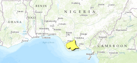
 Map of the Niger Delta swamp forests | |
| Ecology | |
| Realm | Afrotropical |
| Biome | Tropical and subtropical moist broadleaf forests |
| Borders | |
| Geography | |
| Area | 14,500 km2 (5,600 sq mi) |
| Country | Nigeria |
| Coordinates | 5°10′N 6°10′E / 5.167°N 6.167°E |
| Conservation | |
| Conservation status | critical/endangered |
The Niger Delta swamp forests is a tropical moist forest ecoregion in southern Nigeria. It consists of freshwater swamp forests in the Niger Delta of the Niger River. This swamp forest is the second largest in Africa after the Congolian swamp forests.[1][2][3][4] Although there are large cities just outside the ecoregion, the area has been relatively isolated by the difficulty of building roads across the swamps, although this is changing with development of oil and logging industries. Scientific surveys have only begun in recent years, and new species were being identified into the 1990s.[4] Crude oil exploration and pollution has been a threat to forests in the Niger Delta region.[5]
- ^ "Niger Delta swamp forests". World Wildlife Federation. Retrieved June 20, 2020.
- ^ "Map of Ecoregions 2017". Resolve, using WWF data. Retrieved June 20, 2021.
- ^ "Niger Delta swamp forests". Digital Observatory for Protected Areas. Retrieved June 20, 2021.
- ^ a b "Niger Delta swamp forests". The Encyclopedia of Earth. Retrieved June 20, 2021.
- ^ Onyena, Amarachi Paschaline; Sam, Kabari (2020). "A review of the threat of oil exploitation to mangrove ecosystem: Insights from Niger Delta, Nigeria". Global Ecology and Conservation. 22: e00961. doi:10.1016/j.gecco.2020.e00961. S2CID 213767200.
© MMXXIII Rich X Search. We shall prevail. All rights reserved. Rich X Search