Back Selves baixes de Nigèria Catalan Selva de tierras bajas de Nigeria Spanish Kananan Dazuzzukan Najeriya Hausa Foreste di pianura della Nigeria Italian Рівнинні ліси Нігерії Ukrainian Awọn igbo kekere ti Naijiria Yoruba
The biogeographic regionalization of Earth's terrestrial biodiversity, known as Terrestrial Ecoregions of the World (TEOW), is made up of 867 ecoregions that are divided into 14 biomes. In addition to offering a comprehensive map of terrestrial biodiversity, TEOW also provides a global species database for ecological analyses and priority setting, a logical biogeographic framework for large-scale conservation strategies, a map for enhancing biogeographic literacy, and a foundation for the Global 200.
| Nigerian lowland forests | |
|---|---|
 Forest near Benin City | |
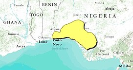
 Map of the Nigerian lowland forests | |
| Ecology | |
| Realm | Afrotropical |
| Biome | Tropical and subtropical moist broadleaf forests |
| Borders | |
| Geography | |
| Area | 67,340 km2 (26,000 sq mi) |
| Countries | |
| Coordinates | 6°48′N 5°00′E / 6.8°N 5.0°E |
| Conservation | |
| Conservation status | critical/endangered |
The Nigerian lowland forests, also known as the Nigerian rainforest, are tropical moist forest ecoregion in southwestern Nigeria and southeastern Benin. The ecoregion is densely populated and home to several large cities, including Lagos, Ibadan, and Benin City. They are considered one of the most biodiverse habitats in the country and are home to a wide range of plant and animal species.[1] There is still significant tree cover, but the remaining enclaves of forest are increasingly fragmented. Though many areas are now used for timber, which provides business for timber traders. The ecoregion is wetter along the coast and drier inland, resulting in bands of vegetation zones that run parallel to the coast for the 400 km length of the region.[2][3][4][5] With the establishment of a Department of Woods and Forests for the Colony and Protectorate of Lagos in 1897 to control timber extraction that had started as early as the 1880s, Nigeria saw the beginning of the first kind of forest management To better control the use of forest resources, the British colonial authority established forest reserves.[6]
Through the implementation of forestry ordinances,16 local communities were granted the freedom to hunt, fish, gather, tap rubber, and farm within designated areas. The majority of the country's forests were reserved before 1930, though some were added in the Niger Delta and the savanna region as late as the 1960s and 1970s. As a result, Nigeria now has 96,000 km2 of designated forest reserves, with 20,700 km2 of those reserves being in the forest ecological zone, and the remaining 82 reserves being in the country's lowland forests, which make up 10,504 km2 or about 15% of the total area.[7] Large sections of forest continued to fall beyond the forest reserves even during this time. Prior to 1960, working plans were used to manage forest reserves, and colonial officials made sure that these plans were strictly followed. The amount of timber being extracted, however, increased by 1960, and once the 1970s saw the start of oil windfall earnings, domestic demand for timber goods skyrocketed. In an effort to boost foreign cash and support local businesspeople, economic trees like mahoganies and iroko (Milicia excelsa), which were formerly controlled by foreigners and expatriates, were selectively logged in huge quantities under laxer forestry rules. These are great economic trees that aid the people in development and building of houses.
To ensure a steady supply of hardwood, the Nigerian forestry departments, like other African forestry authorities, attempted to take up the challenge of silviculture in moist forests beginning in the 1950s. However, the fact that tropical forests are exhaustible after continuous extractive activities was realized very early in the exploitation history.[8] This may have evolved from the original 1906 timber regulations that required loggers to establish plantations or release patches of spontaneous regeneration.[9] Some of the techniques utilized artificial regeneration, but others depended on natural regeneration. The Malayan experience served as the basis for the 1940s adoption of the Nigerian tropical shelter wood system. It involves climbers cutting and opening up the canopy by killing trees thought to be less valuable, allowing valuable tree species to regenerate naturally.[9] 6,15
- ^ "Biodiversity and Protected Areas in West Africa | West Africa". eros.usgs.gov. Retrieved 17 May 2023.
- ^ "Nigerian lowland forests". World Wildlife Federation. Retrieved 20 June 2020.
- ^ "Map of Ecoregions 2017". Resolve, using WWF data. Retrieved 20 June 2021.
- ^ "Nigerian lowland forests". Digital Observatory for Protected Areas. Retrieved 20 June 2021.
- ^ "Nigerian lowland forests". The Encyclopedia of Earth. Retrieved 20 June 2021.
- ^ Okali, D.; Eyog-Matig, O. (2004). Rain forest management for wood production in West and Central Africa: lessons learned on sustainable forest management in Africa.
- ^ Fuwape, J.A.; Akindele, S.O.; Adekunle, V.A. (2006). Forest management and forest landscapes in Nigeria: landscape ecology. Florence: Accademia Italiana di Scienze Forestali.
- ^ Isichei, A.O. (1995). Omo Biosphere Reserve, Current Status, Utilization of Biological Resources and Sustainable Management (Nigeria) (11 ed.). Paris: In UNESCO (ed.) South-South Cooperation Programme on Environmentally Sound Socio-Economic Development in the Humid Tropics working papers No. 11.
- ^ a b Okali, D.; Eyog-Matig, O. (2004). Rain forest management for wood production in West and Central Africa: lessons learned on sustainable forest management in Africa.
© MMXXIII Rich X Search. We shall prevail. All rights reserved. Rich X Search