Back ناينتي سيكس (كارولاينا الجنوبية) Arabic ناينتى سيكس ARZ Ninety Six Catalan Найнти-Сикс (Къилба Каролина) CE Ninety Six CEB Ninety Six, De Carolina Welsh Ninety Six Spanish Ninety Six (Hego Carolina) Basque ناینتی سیکس، کارولینای جنوبی Persian Ninety Six Finnish
Ninety Six, South Carolina | |
|---|---|
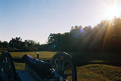
 Sunset over the battlefield at Star Fort | |
 Location of Ninety Six, South Carolina | |
| Coordinates: 34°10′24″N 82°1′18″W / 34.17333°N 82.02167°W | |
| Country | United States |
| State | South Carolina |
| County | Greenwood |
| Government | |
| • Type | Mayor-council government |
| • Mayor | Gregg Brown |
| Area | |
| • Total | 1.82 sq mi (4.72 km2) |
| • Land | 1.82 sq mi (4.72 km2) |
| • Water | 0.00 sq mi (0.00 km2) |
| Elevation | 548 ft (167 m) |
| Population | |
| • Total | 2,076 |
| • Density | 1,139.41/sq mi (439.81/km2) |
| Time zone | UTC−5 (Eastern (EST)) |
| • Summer (DST) | UTC−4 (EDT) |
| ZIP code | 29666 |
| Area code | 864 |
| FIPS code | 45-50290[3] |
| GNIS feature ID | 1249874[4] |
| Website | www |
Ninety Six is a town in Greenwood County, South Carolina, United States. The population was 2,076 at the 2020 census.[5]
- ^ "ArcGIS REST Services Directory". United States Census Bureau. Retrieved October 15, 2022.
- ^ Cite error: The named reference
USCensusDecennial2020CenPopScriptOnlywas invoked but never defined (see the help page). - ^ "U.S. Census website". United States Census Bureau. Retrieved January 31, 2008.
- ^ "US Board on Geographic Names". United States Geological Survey. October 25, 2007. Retrieved January 31, 2008.
- ^ "Geographic Identifiers: 2010 Demographic Profile Data (G001): Ninety Six town, South Carolina". American Factfinder. U.S. Census Bureau. Retrieved February 16, 2017.[dead link]
© MMXXIII Rich X Search. We shall prevail. All rights reserved. Rich X Search