Back Севернобанатски окръг Bulgarian Sjevernobanatski upravni okrug BS Districte de Banat del Nord Catalan Severobanátský okruh Czech Okrug Severni Banat German Distrito de Banato del Norte Spanish Põhja-Banati ringkond Estonian ناحیه بانات شمالی Persian Banat septentrional French Banato Norte Galician
North Banat District
Севернобанатски округ Severnobanatski okrug Észak-bánsági körzet | |
|---|---|
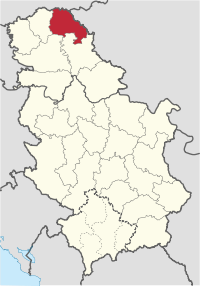 Location of the North Banat District within Serbia | |
| Coordinates: 45°50′N 20°27′E / 45.833°N 20.450°E | |
| Country | |
| Province | |
| Administrative center | Kikinda |
| Government | |
| • Commissioner | Nikola Lukač |
| Area | |
| • Total | 2,329 km2 (899 sq mi) |
| Population (2022 census) | |
| • Total | 117,896 |
| • Density | 51.2/km2 (133/sq mi) |
| ISO 3166 code | RS-03 |
| Municipalities | 6 |
| Settlements | 50 |
| - Cities and towns | 7 |
| - Villages | 43 |
| Website | www |


The North Banat District (Serbian: Севернобанатски округ, romanized: Severnobanatski okrug, pronounced [sêʋeːrnobǎnaːtskiː ôkruːɡ]; Hungarian: Észak-bánsági körzet) is one of seven administrative districts of the autonomous province of Vojvodina, Serbia. It lies in the geographical regions of Banat and Bačka. According to the 2022 census, the district has a population of 117,896 inhabitants. The administrative center of the district is the city of Kikinda.
© MMXXIII Rich X Search. We shall prevail. All rights reserved. Rich X Search

