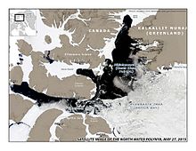


The North Water Polynya (NOW), or Pikialasorsuaq[2] to Inuit in Greenland and Sarvarjuaq[3] to Inuit in Canada, is a polynya (area of year-round open water surrounded by sea ice) that lies between Greenland and Canada in northern Baffin Bay. The world's largest Arctic polynya at about 85,000 km2 (33,000 sq mi),[4] it creates a warm microclimate that provides a refuge for narwhal, beluga, walrus, and bowhead whales to feed and rest. While thin ice forms in some areas, the polynya is kept open by wind, tides and an ice bridge on its northern edge. Named the "North Water" by 19th century whalers who relied on it for spring passage, this polynya is one of the most biologically productive marine areas in the Arctic Ocean.[5][6]
- ^ Worldview at NASA
- ^ "An Inuit strategy for the future of Pikialasorsuaq".
- ^ "Sarvarjuaq and Qikiqtait: Inuit Stewardship and the Blue Economy in Nunavut's Qikiqtani region".
- ^ Dunbar, M (1969). "The geographical position of the North Water". Arctic. 22 (4): 438–441. doi:10.14430/arctic3235.
- ^ Nutt, D.C. (1969). "The North Water of Baffin Bay". Polar Notes. 9: 1–25.
- ^ Stirling, I (1980). "The Biological Importance of Polynyas in the Canadian Arctic". Arctic. 33 (2): 303–315. CiteSeerX 10.1.1.562.8136. doi:10.14430/arctic2563.
© MMXXIII Rich X Search. We shall prevail. All rights reserved. Rich X Search
