| Northern Khorat Plateau moist deciduous forests | |
|---|---|
 Rock formation in Phu Kao–Phu Phan Kham National Park | |
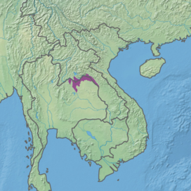
 Ecoregion territory (in purple) | |
| Ecology | |
| Realm | Indomalayan |
| Biome | Tropical and subtropical moist broadleaf forests |
| Borders | |
| Geography | |
| Area | 16,835 km2 (6,500 sq mi) |
| Country | Laos, Thailand |
| Coordinates | 18°15′N 103°45′E / 18.25°N 103.75°E |
| Conservation | |
| Protected | 2.35%[1] |
The Northern Khorat Plateau moist deciduous forests ecoregion (WWF ID: IM0138) covers a small area on the border between northeastern Thailand and Laos, in the transition zone between the drier Khorat Plateau to the south and the wetter Annamite Range and Luang Prabang Range mountains to the north. Much of the ecoregion has been converted to agriculture along the floodplain of the middle course of the Mekong River.[2][3][1]
- ^ a b "Northern Khorat Plateau moist deciduous forests". Digital Observatory for Protected Areas. Retrieved 2 June 2023.
- ^ "Northern Khorat Plateau moist deciduous forests". World Wildlife Federation. Retrieved March 21, 2020.
- ^ "Map of Ecoregions 2017". Resolve, using WWF data. Retrieved September 14, 2019.
© MMXXIII Rich X Search. We shall prevail. All rights reserved. Rich X Search
