This article needs additional citations for verification. (September 2009) |
Norwichtown Historic District | |
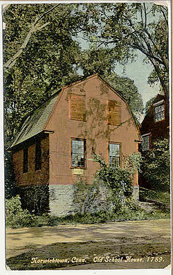
 Old School House | |
| Location | Roughly bounded by Huntington Ln., Scotland Rd., and Washington, Town and E. Town Sts., Norwich, Connecticut |
|---|---|
| Coordinates | 41°32′52″N 72°5′33″W / 41.54778°N 72.09250°W |
| Area | 110 acres (45 ha) |
| Architect | Multiple |
| Architectural style | Colonial, Georgian |
| NRHP reference No. | 73001951[1] |
| Added to NRHP | January 17, 1973 |
Norwichtown is a historic neighborhood in the city of Norwich, Connecticut. It is generally the area immediately north of the Yantic River between I-395 and Route 169.[citation needed]
The portion of the neighborhood from the Norwichtown Green and east of it is a locally designated historic district that was also listed on the National Register of Historic Places in 1973 as the Norwichtown Historic District.[2] The district includes 48 contributing buildings and one other contributing site over 110 acres (45 ha) area.
The earliest settlement of Norwich, in 1659, was in Norwichtown. Initial settlement, by 35 English settlers who relocated from Saybrook Fort under the leadership of Major John Mason and bought land from Uncas, sachem of the Mohegans, was centered on the Norwichtown Green.[3][4]
- ^ "National Register Information System". National Register of Historic Places. National Park Service. July 9, 2010.
- ^ Cite error: The named reference
towngreenswas invoked but never defined (see the help page). - ^ Walking Guide to Historic Norwichtown (1995), The Last Green Valley, Inc.
- ^ Carol Davidge and Erwin Goldstein, "Norwichtown Green & Old Burying Grounds," Walking Guide to the Quinebaug and Shetucket Rivers Valley National Heritage Corridor, page 5
© MMXXIII Rich X Search. We shall prevail. All rights reserved. Rich X Search


