Back نورت دام دي بونسيكورس (كيبك) Arabic Notre-Dame-de-Bonsecours CEB Notre-Dame-de-Bonsecours (Quebec) Basque نوتر-دام-دو-بونسکور، کبک Persian Notre-Dame-de-Bonsecours French Notre-Dame-de-Bonsecours Swedish
Notre-Dame-de-Bonsecours | |
|---|---|
 Village entrance | |
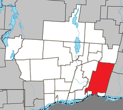
 Location within Papineau RCM | |
| Coordinates: 45°42′N 74°52′W / 45.700°N 74.867°W[1] | |
| Country | Canada |
| Province | Quebec |
| Region | Outaouais |
| RCM | Papineau |
| Constituted | March 7, 1918 |
| Government | |
| • Mayor | Denis Beauchamp |
| • Federal riding | Argenteuil—Papineau—Mirabel |
| • Prov. riding | Papineau |
| Area | |
| • Total | 281.30 km2 (108.61 sq mi) |
| • Land | 258.36 km2 (99.75 sq mi) |
| Population (2021)[3] | |
| • Total | 285 |
| • Density | 1.1/km2 (3/sq mi) |
| • Pop 2016-2021 | |
| • Dwellings | 166 |
| Time zone | UTC−5 (EST) |
| • Summer (DST) | UTC−4 (EDT) |
| Postal code(s) | |
| Area code | 819 |
| Highways | |
| Website | www |
Notre-Dame-de-Bonsecours is a municipality in the Outaouais region of Quebec, Canada. It is located along the Ottawa River, about 55 kilometres (34 mi) east of Gatineau. It was formerly known as Notre-Dame-de-Bon-Secours-Partie-Nord. It is the least populated municipality in the Papineau Regional County Municipality.
The northern portion of the municipality is undeveloped wilderness, mostly part of the Kenauk Reserve. This 260 square kilometres (100 sq mi) protected wilderness domain was formerly known as "Reserve de la Petite Nation", but is now a privately owned fish and game reserve of Château Montebello.[4]
- ^ Cite error: The named reference
toponymiewas invoked but never defined (see the help page). - ^ a b Cite error: The named reference
mamrotwas invoked but never defined (see the help page). - ^ a b Cite error: The named reference
cp21was invoked but never defined (see the help page). - ^ "Fairmont Kenauk Hotel History". Retrieved 2008-10-24.
© MMXXIII Rich X Search. We shall prevail. All rights reserved. Rich X Search
