Back أوفانتو Arabic نهر اوفانتو ARZ Офанта Byelorussian Офанто Bulgarian Ofanto Catalan Ofanto Czech Офанто CV Ofanto Spanish Ofanto Estonian Ofanto Basque
You can help expand this article with text translated from the corresponding article in Italian. (July 2012) Click [show] for important translation instructions.
|
| Ofanto | |
|---|---|
 | |
 | |
| Location | |
| Country | Italy |
| Physical characteristics | |
| Source | |
| • location | near Nusco |
| • elevation | 715 m (2,346 ft) |
| Mouth | Adriatic Sea |
• location | Gulf of Manfredonia |
• coordinates | 41°21′33″N 16°11′51″E / 41.3592°N 16.1976°E |
• elevation | 0 m (0 ft) |
| Length | 134 km (83 mi)[1][2] 170 km (110 mi)[3][4] |
| Basin size | 2,780 km2 (1,070 sq mi) |
| Discharge | |
| • average | 15 cubic metres per second (530 cu ft/s) |
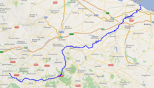
The Ofanto (Italian pronunciation: [ˈɔːfanto]), known in ancient times as Aufidus or Canna,[5] is a 134 or 170 km (83 or 110 mi, depending on the sources) river in southern Italy that flows through the regions of Campania, Basilicata, and Apulia, into the Gulf of Manfredonia near Barletta.
- ^ Saul Bernard Cohen (2008). The Columbia Gazetteer of the World. Columbia University Press. p. 2773. ISBN 9780231145541.
- ^ Astrid Pellicano (2004). Terre e confini del Sud: la dinamica dell'articolazione amministrativa nelle regioni meridionali d'Italia, 1861-2001. Memorie della Società geografica italiana (in Italian). Vol. 71. Società geografica italiana. p. 152. ISBN 9788888692142. ISSN 0391-5190.
- ^ "Ofanto". Treccani (in Italian).
- ^ "Òfanto". Sapere (in Italian).
- ^ Talbert, Richard J. A., ed. (2000). Barrington Atlas of the Greek and Roman World: Map-By-Map Directory. Vol. I. Princeton, NJ and Oxford, UK: Princeton University Press. p. 675. ISBN 0-691-04945-9.
© MMXXIII Rich X Search. We shall prevail. All rights reserved. Rich X Search