Back مقاطعة أوهايو (كنتاكي) Arabic Ohio County, Kentucky BAR Охайо (окръг, Кентъки) Bulgarian ওহাইও কাউন্টি, কেন্টাকি BPY Ohio Gông (Kentucky) CDO Огайо (гуо, Кентукки) CE Ohio County (kondado sa Tinipong Bansa, Kentucky) CEB Ohio County, Kentucky Welsh Ohio County (Kentucky) German Condado de Ohio (Kentucky) Spanish
Ohio County | |
|---|---|
 Ohio County Courthouse in Hartford | |
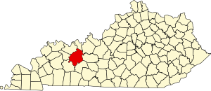
 Location within the U.S. state of Kentucky | |
 Kentucky's location within the U.S. | |
| Coordinates: 37°28′N 86°50′W / 37.47°N 86.84°W | |
| Country | |
| State | |
| Founded | December 17, 1798 |
| Named for | The Ohio River |
| Seat | Hartford |
| Largest city | Beaver Dam |
| Government | |
| • Judge/Executive | David Johnston |
| Area | |
| • Total | 596 sq mi (1,540 km2) |
| • Land | 587 sq mi (1,520 km2) |
| • Water | 9.0 sq mi (23 km2) 1.5% |
| Population (2020) | |
| • Total | 23,772 |
| • Estimate (2023) | 23,626 |
| • Density | 40/sq mi (15/km2) |
| Time zone | UTC−6 (Central) |
| • Summer (DST) | UTC−5 (CDT) |
| Congressional district | 2nd |
| Website | ohiocounty |
Ohio County is a county located in the U.S. state of Kentucky. As of the 2020 census, the population was 23,772.[1] Its county seat is Hartford, and its largest city is Beaver Dam.[2] The county is named after the Ohio River, which originally formed its northern boundary. It is a moist county, which means that the sale of alcohol is only legal within certain city limits.
- ^ "State & County QuickFacts". United States Census Bureau. Retrieved August 28, 2022.
- ^ "Find a County". National Association of Counties. Archived from the original on May 31, 2011. Retrieved June 7, 2011.
© MMXXIII Rich X Search. We shall prevail. All rights reserved. Rich X Search