 | ||||
| Route information | ||||
| Maintained by ODOT | ||||
| Length | 2.87 mi[1] (4.62 km) | |||
| Existed | 1937–present | |||
| Major junctions | ||||
| West end | ||||
| East end | ||||
| Location | ||||
| Country | United States | |||
| State | Ohio | |||
| Counties | Pike | |||
| Highway system | ||||
| ||||
| ||||
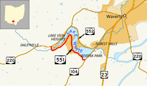
State Route 551 (SR 551) is an east-west state highway in southern Ohio. Its western terminus is at a T-intersection with SR 220 about four miles (6.4 km) southwest of Waverly, and its eastern terminus is at a T-intersection with SR 104 approximately two and a half miles (4.0 km) southwest of Waverly. Existing entirely within Pike County's Pee Pee Township, SR 551 follows the south shore of Lake White, while SR 552 follows the north shore. Lake White State Park is located near SR 551's western terminus.
- ^ "DESTAPE - Pike County" (PDF). Ohio Department of Transportation. June 24, 2015. Retrieved November 8, 2015.
© MMXXIII Rich X Search. We shall prevail. All rights reserved. Rich X Search

