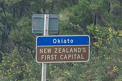
Okiato | |
|---|---|
 New Zealand's First Capital | |
 | |
| Coordinates: 35°18′14″S 174°07′19″E / 35.304°S 174.122°E | |
| Country | New Zealand |
| Region | Northland Region |
| District | Far North District |
| Ward | Bay of Islands/Whangaroa |
| Founded | 1840 |
| Electorates | |
| Government | |
| • Territorial Authority | Far North District Council |
| • Regional council | Northland Regional Council |
| Area | |
| • Total | 0.33 km2 (0.13 sq mi) |
| Population (June 2023)[2] | |
| • Total | 210 |
| • Density | 640/km2 (1,600/sq mi) |
| Postcode | 0272 |

Okiato or Old Russell is a small town in the Bay of Islands, New Zealand, 7 kilometres (4.3 mi) south of present-day Russell. It was founded in 1840 and served as New Zealand's first national capital until 1841, when the seat of government was moved to Auckland. The car ferry across the Bay of Islands, which provides the main access to Russell, runs between Okiato and Opua.
- ^ Cite error: The named reference
Areawas invoked but never defined (see the help page). - ^ "Subnational population estimates (RC, SA2), by age and sex, at 30 June 1996-2023 (2023 boundaries)". Statistics New Zealand. Retrieved 25 October 2023. (regional councils); "Subnational population estimates (TA, SA2), by age and sex, at 30 June 1996-2023 (2023 boundaries)". Statistics New Zealand. Retrieved 25 October 2023. (territorial authorities); "Subnational population estimates (urban rural), by age and sex, at 30 June 1996-2023 (2023 boundaries)". Statistics New Zealand. Retrieved 25 October 2023. (urban areas)
© MMXXIII Rich X Search. We shall prevail. All rights reserved. Rich X Search
