Back مقاطعة أولمستيد (مينيسوتا) Arabic Olmsted County, Minnesota BAR Олмстед (окръг, Минесота) Bulgarian ওলমস্টেড কাউন্টি, মিনেসোটা BPY Olmsted Gông (Minnesota) CDO Олмстед (гуо, Миннесота) CE Olmsted County CEB Olmsted County, Minnesota Welsh Olmsted County Danish Olmsted County German
Olmsted County | |
|---|---|
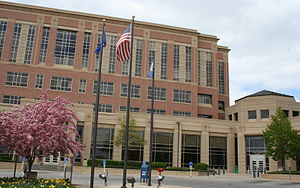
 Olmsted County Government Center (pre-expansion) | |
 Location within the U.S. state of Minnesota | |
 Minnesota's location within the U.S. | |
| Coordinates: 44°00′N 92°24′W / 44°N 92.4°W | |
| Country | |
| State | |
| Founded | February 20, 1855 |
| Named for | David Olmsted |
| Seat | Rochester |
| Largest city | Rochester |
| Area | |
| • Total | 655 sq mi (1,700 km2) |
| • Land | 653 sq mi (1,690 km2) |
| • Water | 1.5 sq mi (4 km2) 0.2% |
| Population (2020) | |
| • Total | 162,847 |
| • Estimate (2023) | 164,784 |
| • Density | 249/sq mi (96/km2) |
| Time zone | UTC−6 (Central) |
| • Summer (DST) | UTC−5 (CDT) |
| Congressional district | 1st |
| Website | www |
Olmsted County is a county in the U.S. state of Minnesota. As of the 2020 census, the population is 162,847.[1] Its county seat and most populous city is Rochester.[2]
Olmsted County is part of the Rochester Metropolitan Statistical Area.
- ^ "State & County QuickFacts". United States Census Bureau. Retrieved April 8, 2023.
- ^ "Find a County". National Association of Counties. Retrieved June 7, 2011.
© MMXXIII Rich X Search. We shall prevail. All rights reserved. Rich X Search