| Olmsted Locks and Dam (Locks and Dams 52 and 53 Replacement Project) | |
|---|---|
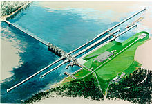
 Rendering of Olmsted Locks and Dam | |
| Location | |
| Coordinates | 37°11′01″N 89°03′50″W / 37.18361°N 89.06389°W |
| Construction began | December 1995 |
| Opening date | August 2018 |
| Construction cost | Estimated $3 billion+ (as of February 2018) |
| Operator(s) | United States Army Corps of Engineers Louisville District |
| Dam and spillways | |
| Impounds | Ohio River |
| Height | 62 feet (19 m) |
| Length | 2,596 feet (791 m) |
The Olmsted Locks and Dam is a locks and wicket dam on the Ohio River at river mile 964.4. The project is intended to reduce tow and barge delays by replacing the existing older, and frequently congested, locks and dams Number 52 and Number 53. The locks are located about 17 miles upstream from the confluence of the Ohio and Mississippi rivers at Olmsted, Illinois.
The Olmsted has been operational since August 2018 while the removal of Locks and Dams 52 and 53 should be completed around 2022.[1] The project is both the largest and the most expensive inland waterway project ever undertaken in the United States.[2]
- ^ Byrne, Shelley (April 1, 2022). "Demolition At Ohio River L&Ds 52, 53 To Wrap Up In 2022". The Waterways Journal. Retrieved September 24, 2023.
- ^ "Olmsted Locks and Dam". Louisville District. United States Army Corps of Engineers. Retrieved February 21, 2018.
© MMXXIII Rich X Search. We shall prevail. All rights reserved. Rich X Search
