| Orford Ness | |
|---|---|
| Near Orford, Suffolk | |
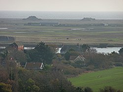
 Looking towards Orford Ness from Orford castle | |
| Coordinates | 52°04′53″N 01°33′31″E / 52.08139°N 1.55861°E |
| Type | National Nature Reserve, Site of Special Scientific Interest, internationally important site for nature conservation, former military test site |
| Site information | |
| Operator | Ministry of Defence, Atomic Weapons Research Establishment, National Trust for Places of Historic Interest or Natural Beauty |
| Status | Inactive |
| Site history | |
| In use | 1913 – early 1983 |
Orford Ness is a cuspate foreland shingle spit on the Suffolk coast in Great Britain, linked to the mainland at Aldeburgh and stretching along the coast to Orford and down to North Weir Point, opposite Shingle Street. It is divided from the mainland by the River Alde, and was formed by longshore drift along the coast. The material of the spit comes from places further north, such as Dunwich. Near the middle point of its length, at the foreland point or 'Ness', once stood Orfordness Lighthouse,[1] demolished in summer 2020 owing to the encroaching sea.[2] In the name of the lighthouse (and the radio transmitting station – see below), 'Orfordness' is written as one word.
- ^ "Orfordness Lighthouse". Trinity House. Archived from the original on 31 October 2007. Retrieved 11 October 2007.
- ^ "Orfordness Lighthouse: Historic Suffolk landmark reduced to rubble". BBC. 11 August 2020.
© MMXXIII Rich X Search. We shall prevail. All rights reserved. Rich X Search

