Back Спартыўная карта Byelorussian Orientierungslaufkarte German Orienteerumiskaart Estonian Carta da orientamento Italian Orientēšanās karte Latvian/Lettish Orienteringskart NB Спортивная карта Russian Orientacijska karta Slovenian Orienteringskarta Swedish Спорт картасы Tatar

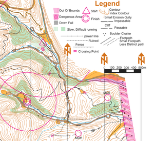
An orienteering map is a map specially prepared for use in orienteering events. It is a large-scale topographic map with extra markings to help the participant navigate through the course.
These maps are much more detailed than general-purpose topographic maps, and incorporate a standard symbology designed to be useful to anyone, regardless of native language. In addition to indicating the topography of the terrain with contour lines, orienteering maps also show forest density, water features, clearings, trails and roads, earthen banks and rock walls, ditches, wells and pits, fences and power lines, buildings, boulders, and other features of the terrain.
Orienteering maps meant for competition in forested areas are usually 1:15 000 or 1:10 000 scale[1] and 1:4.000 for sprint maps in cities, and parks.
The International Orienteering Federation (IOF) publishes the standard for orienteering maps, including:
- ISOM (International Specification for Orienteering Maps), used for FootO forest maps.
- ISSprOM (International Specification for Sprint Orienteering Maps), used for FootO sprint and TrailO maps.
- ISSkiOM (International Specification for Ski Orienteering Maps), used for SkiO maps.
- ISMTBOM (International Specification for Mountain Bike Orienteering Maps), used for MTBO maps.

- ^ Zentai, László, ed. (2000) International Drawing Specifications for Orienteering Maps (ISOM2000). International Orienteering Federation.
© MMXXIII Rich X Search. We shall prevail. All rights reserved. Rich X Search