Back Отвацк Byelorussian Отвоцк Bulgarian Otwock (kapital sa munisipyo) CEB Otwock Danish Otwock German Ότφοτσκ Greek Otwock Esperanto Otwock Estonian Otwock Basque اوتووتسک Persian
Otwock | |
|---|---|
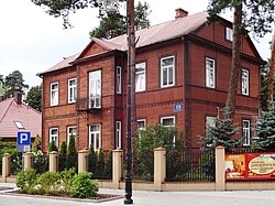
 Świdermajer-styled house in Otwock | |
| Coordinates: 52°7′N 21°16′E / 52.117°N 21.267°E | |
| Country | |
| Voivodeship | |
| County | Otwock |
| Gmina | Otwock (urban gmina) |
| Established | 1877 |
| City rights | 9 November 1916 |
| Government | |
| • City mayor | Jarosław Margielski (PiS) |
| Area | |
| • Total | 47.33 km2 (18.27 sq mi) |
| Elevation | 100 m (300 ft) |
| Population (2019) | |
| • Total | 44,635 |
| • Density | 940/km2 (2,400/sq mi) |
| Time zone | UTC+1 (CET) |
| • Summer (DST) | UTC+2 (CEST) |
| Postal code | 05-400 to 05-402 |
| Area code | +48 022 |
| Car plates | WOT |
| Highways | |
| Voivodeship roads | |
| Website | http://www.otwock.pl |
Otwock [ˈɔtfɔt͡sk] (Yiddish: אָטוואָצק) is a city in the Masovian Voivodship in east-central Poland, some 23 kilometres (14 mi) southeast of Warsaw, with 44,635 inhabitants (2019). Otwock is a part of the Warsaw metropolitan area. It is situated on the right bank of Vistula River below the mouth of Świder River. Otwock is home to a unique architectural style called Świdermajer.
It is the capital of Otwock County. The town covers the area of 47 square kilometres (18 sq mi). Forested areas make up 23% of the territory, and there are several nature reserves.
© MMXXIII Rich X Search. We shall prevail. All rights reserved. Rich X Search


