
The following outline is provided as an overview of and topical guide to Djibouti:
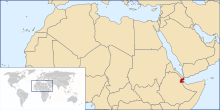
Djibouti – country located in the Horn of Africa. It is bordered by Eritrea in the north, Ethiopia in the west and south, and Somalia in the southeast. The remainder of the border is formed by the Red Sea and the Gulf of Aden at the east. Djibouti occupies a total area of just 23,200 km2 (8,958 sq mi). In antiquity, the territory was part of the Land of Punt. Djibouti is a multi-ethnic nation, with a population of over 790,000 inhabitants. The Somali and Afar make up the two largest ethnic groups. Both speak Afro-Asiatic languages, which serve as recognized national languages. Arabic and French constitute the country's two official languages. About 94% of residents adhere to Islam, a religion that has been predominant in the region for more than 1,000 years.[1] Djibouti is strategically located near the world's busiest shipping lanes, controlling access to the Red Sea and Indian Ocean.
- ^ "Djibouti". The World Factbook. CIA. February 5, 2013. Retrieved February 26, 2013.
© MMXXIII Rich X Search. We shall prevail. All rights reserved. Rich X Search


