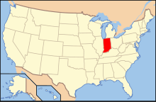
The following outline is provided as an overview of and topical guide to the U.S. state of Indiana:
Indiana – a U.S. state, was admitted to the United States as the 19th state on December 11, 1816. It is located in the midwestern United States and Great Lakes Region of North America. With 6,483,802 residents, as of the 2010 U.S. Census, the state is ranked 15th in population and 16th in population density.[1][2][3] Indiana is ranked 38th in land area[1] and is the smallest state in the contiguous U.S. west of the Appalachian Mountains.[4] Indiana's capital and largest city is Indianapolis,[5] the second largest of any state capital and largest state capital east of the Mississippi River.[citation needed]
- ^ a b "States ranked by population density". Worldatlas.com. 21 June 2023.
- ^ "Guide to State and Local Census Geography–Indiana, 2010 U.S. Census". U.S. Census Bureau. Retrieved 2012-08-09.
- ^ "State & County QuickFacts Indiana". U.S. Census Bureau. Archived from the original on 2012-04-23. Retrieved 2012-08-09.
- ^ "The Geography of Indiana". Netstate. Retrieved 2012-08-13.
- ^ "Guide to State and Local Census Geography – Indiana". U.S. Census Bureau. 2011-12-22. Retrieved 2012-08-13.
© MMXXIII Rich X Search. We shall prevail. All rights reserved. Rich X Search


