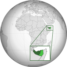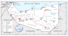


The following outline is provided as an overview and topical guide to Somaliland:
Somaliland – is an internationally unrecognised country.[1] The government of Somaliland regards the territory as the successor state to the British Somaliland protectorate, which was independent for a few days in 1960 as the State of Somaliland,[2][3] before voluntarily uniting with the Trust Territory of Somalia (the former Italian Somaliland) later the same week to form the Somali Republic.[2][3][4][5][6]
- ^ "The Transitional Federal Charter of the Somali Republic" (PDF). University of Pretoria. 2004-02-01. Archived from the original (PDF) on 2008-12-18. Retrieved 2010-02-02. "The Somali Republic shall have the following boundaries. (a) North; Gulf of Aden. (b) North West; Djibouti. (c) West; Ethiopia. (d) South south-west; Kenya. (e) East; Indian Ocean."
- ^ a b "Somaliland Marks Independence After 73 Years of British Rule" (fee required). The New York Times. 1960-06-26. p. 6. Retrieved 2008-06-20.
- ^ a b "How Britain said farewell to its Empire". BBC News. 2010-07-23.
- ^ Encyclopædia Britannica, The New Encyclopædia Britannica, (Encyclopædia Britannica: 2002), p.835
- ^ "The dawn of the Somali nation-state in 1960". Buluugleey.com. Archived from the original on 2009-01-16. Retrieved 2009-02-25.
- ^ "The making of a Somalia state". Strategypage.com. 2006-08-09. Retrieved 2009-02-25.
© MMXXIII Rich X Search. We shall prevail. All rights reserved. Rich X Search


