Back Oyapock ALS نهر اوياپوك ARZ Oiapoque (stêr) Breton Rio Oiapoque (suba sa Brasil) CEB Oyapock Czech Ояпок (юханшыв) CV Oyapock German Río Oyapoque Spanish Oyapock Finnish Oyapock French
This article needs additional citations for verification. (April 2014) |
| Oyapock | |
|---|---|
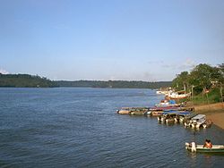
 View of the Oyapock River from Brazil toward French Guiana | |
 Guyane Oyapock River map | |
| Location | |
| Countries | Brazil and France |
| Physical characteristics | |
| Source | |
| • location | Tumuk Humak Mountains |
| Mouth | |
• location | Atlantic Ocean |
• coordinates | 04°14′08″N 51°36′53″W / 4.23556°N 51.61472°W |
| Length | 403 km (250 mi) |
| Basin size | 30,869 km2 (11,919 sq mi) |
| Discharge | |
| • location | Near mouth |
| • average | 1,457 m3/s (51,500 cu ft/s) |
| Basin features | |
| Bridges | Oyapock River Bridge |
The Oyapock or Oiapoque (/ˈɔɪ.əpɒk, ɔɪ.əˈpoʊki/; French: Fleuve Oyapock [flœv ojapɔk]; Portuguese: Rio Oiapoque [ˈʁiu ɔjɐˈpɔki]) is a 403-kilometre (250 mi) long river in South America that forms most of the border between the French overseas department of French Guiana and the Brazilian state of Amapá.[1][2]
- ^ Sandre. "Fiche cours d'eau - oyapock, l' (fleuve); kerindioutou (riviere) (6---0000)".
- ^ "Oyapock: the bridge to discord?". France 24. 2012-09-07. Archived from the original on 2014-04-14. Retrieved 2014-04-13.
© MMXXIII Rich X Search. We shall prevail. All rights reserved. Rich X Search