Back بحيرة بانغونق Arabic Panqonq-Tso gölü Azerbaijani पांगोंग त्सो Bihari প্যাঙ্গং হ্রদ Bengali/Bangla Pangong Tso Catalan Pangong Tso CEB Pangong Tso Czech Пангонг-Цо CV Pangong Tso Danish Pangong Tso German
| Pangong Tso | |
|---|---|
 A view of Pangong Tso from space | |
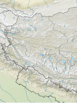
| Location | Leh district (Ladakh, India), Rutog County (Tibet, China) |
| Coordinates | 33°43′04.59″N 78°53′48.48″E / 33.7179417°N 78.8968000°E |
| Type | Soda lake dimictic lake (east basin)[1] cold monomictic lake (west basin)[citation needed] |
| Basin countries | China, India |
| Max. length | 134 km (83 mi) |
| Max. width | 5 km (3.1 mi) |
| Surface area | approx. 700 km2 (270 sq mi) |
| Max. depth | 330 ft. (100 m) |
| Surface elevation | 4,225 metres (13,862 ft)[2] |
| Frozen | during winter |
| Pangong Tso | |||||||||
|---|---|---|---|---|---|---|---|---|---|
| Chinese name | |||||||||
| Traditional Chinese | 班公錯 | ||||||||
| Simplified Chinese | 班公错 | ||||||||
| |||||||||
| Tibetan name | |||||||||
| Tibetan | སྤང་གོང་མཚོ | ||||||||
| |||||||||
| Tsomo Nganglha Ringpo | |||||||||
|---|---|---|---|---|---|---|---|---|---|
| Chinese name | |||||||||
| Traditional Chinese | 錯木昂拉仁波 | ||||||||
| Simplified Chinese | 錯木昂拉仁波 | ||||||||
| |||||||||
| Tibetan name | |||||||||
| Tibetan | མཚོ་མོ་ངང་ལྷ་རིང་པོ | ||||||||
| |||||||||
Pangong Tso or Pangong Lake (Tibetan: སྤང་གོང་མཚོ;[3] Chinese: 班公错; pinyin: Bān gōng cuò; Hindi: पैंगोंग झील, romanized: Paiṅgoṅg jhīl) is an endorheic lake spanning eastern Ladakh and West Tibet situated at an elevation of 4,225 m (13,862 ft). It is 134 km (83 mi) long and divided into five sublakes, called Pangong Tso, Tso Nyak, Rum Tso (twin lakes) and Nyak Tso. Approximately 50% of the length of the overall lake lies within Tibet administered by China, 40% in Indian-administered Ladakh, and the remaining 10% is disputed and is a de facto buffer zone between India and China. The lake is 5 km (3.1 mi) wide at its broadest point. All together it covers almost 700 km2. During winter the lake freezes completely, despite being saline water. It has a land-locked basin separated from the Indus River basin by a small elevated ridge, but is believed to have been part of the latter in prehistoric times.[4]
- ^ Wang, M., Hou, J. and Lei, Y., 2014. Classification of Tibetan lakes based on variations in seasonal lake water temperature. Chinese Science Bulletin, 59(34): 4847-4855.
- ^ Dortch et al., Catastrophic partial drainage of Pangong Tso (2011), p. 111.
- ^ "Ngari prefecture". Geographical names of Tibet AR (China). Institute of the Estonian Language. 3 June 2018. Archived from the original on 10 January 2020. Retrieved 9 January 2020.
- ^ "River basins with Major and medium dams & barrages location map in India, WRIS" (Adobe Flash Player version 10.0.0 or greater). Archived from the original on 4 March 2016.
© MMXXIII Rich X Search. We shall prevail. All rights reserved. Rich X Search

