Back ضاحية بارا Arabic Distrikt Para CEB Para (distrikt) Danish Para (Distrikt) German Para (distrikto) Esperanto Distrito de Para Spanish ناحیه پارا Persian Para (Suriname) Finnish Para (Suriname) French Para (Distrikt) FRR
Para District | |
|---|---|
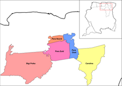
 Resorts in Para | |
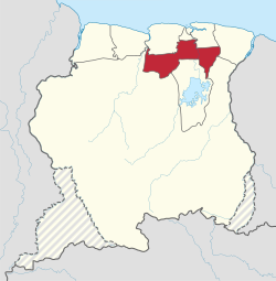
 Map of Suriname showing Para district | |
| Coordinates: 5°26′N 55°13′W / 5.433°N 55.217°W | |
| Country | Suriname |
| District | Para |
| Capital | Onverwacht |
| Area | |
| • Total | 5,393 km2 (2,082 sq mi) |
| Population (2012 census)[1] | |
| • Total | 24,700 |
| • Density | 4.6/km2 (12/sq mi) |
| Time zone | UTC-3 |
| ISO 3166 code | SR-PR |
Para is a district of northern Suriname. Para's capital city is Onverwacht, with other towns including Paranam, and Zanderij. Para has a population of 24,700 and an area of 5,393 km2.[1] The district is the mining and forestry centre of Suriname, with many large bauxite mining operations operating. The district is a mixture of forest and savannas.[2]
- ^ a b "Resorts in Suriname Census 2012" (PDF). Retrieved 26 May 2020.
- ^ "Distrikt Para 1" (in Dutch). Retrieved 28 May 2020.
© MMXXIII Rich X Search. We shall prevail. All rights reserved. Rich X Search