Back إقليم باردوبيتسه Arabic Pardubitse diyarı Azerbaijani پاردوبیتسه اوستانی AZB Пардубіцкі край Byelorussian Пардубіцкі край BE-X-OLD Пардубицки край Bulgarian Rannvro Pardubice Breton Pardubički kraj BS Regió de Pardubice Catalan Пардубицен мохк CE
Pardubice Region
Pardubický kraj | |
|---|---|
 Kunětická hora from air | |
 | |
| Coordinates: 49°52′N 16°10′E / 49.87°N 16.17°E | |
| Country | Czech Republic |
| Capital | Pardubice |
| Districts | Pardubice District, Chrudim District, Svitavy District, Ústí nad Orlicí District |
| Government | |
| • Governor | Martin Netolický (ČSSD) |
| Area | |
| • Total | 4,518.63 km2 (1,744.65 sq mi) |
| Highest elevation | 1,424 m (4,672 ft) |
| Population (2024-01-01)[1] | |
| • Total | 530,560 |
| • Density | 120/km2 (300/sq mi) |
| GDP | |
| • Total | CZK 237.131 billion (€9.248 billion) |
| ISO 3166 code | CZ-53 |
| Vehicle registration | E |
| Website | www.pardubickykraj.cz |
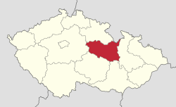
Pardubice Region (Czech: Pardubický kraj; German: Pardubitzer Region, pronounced [paːʁˈdyːˈbɪt͡sɐ ʁeˈɡi̯oːn]; Polish: Kraj pardubicki) is an administrative unit (Czech: kraj) of the Czech Republic, located mainly in the eastern part of its historical region of Bohemia, with a small part in northwestern Moravia. It is named after its capital Pardubice. As an administrative unit, Pardubice Region has existed three times in the course of history. It was established for the first time in 1850, and extended from Český Brod to the Bohemian-Moravian border. In its second existence, it was one of 19 regions as they were set between 1949 and 1960. After 1960, Pardubice became the capital of Pardubice district, which was part of the Eastern Bohemian Region (capital Hradec Králové). The Pardubice Region, as it is now, was reestablished in 2000.
- ^ "Population of cohesion regions, regions and districts of the Czech Republic, 1 January 2024". Czech Statistical Office. Retrieved 17 May 2024.
- ^ https://www.czso.cz/csu/xb/regionalni_hdp Language - Czech, Access date - 01/30/2021
© MMXXIII Rich X Search. We shall prevail. All rights reserved. Rich X Search

