Back Bosques xéricos de Paropamisus Spanish جنگلهای خشک پاروپامیسوس Persian Boschi xerofili del Paropamiso Italian Склерофітні рідколісся Паропамізу Ukrainian
| Paropamisus xeric woodlands | |
|---|---|
 | |
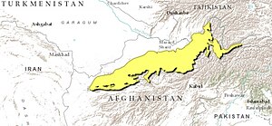
 Ecoregion territory (in purple) | |
| Ecology | |
| Realm | Palearctic |
| Biome | Deserts and xeric shrublands |
| Geography | |
| Area | 92,804 km2 (35,832 sq mi) |
| Country | Afghanistan, Tajikistan |
| Coordinates | 36°15′N 66°45′E / 36.25°N 66.75°E |
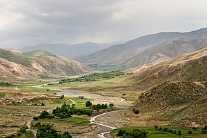
The Paropamisus xeric woodlands ecoregion (WWF ID: PA1322) covers the portion of northeastern Afghanistan north of the central mountain range and the Hindu Kush Mountains. The name is derived from the Old Persian name for the region, Parupraesanna ("Beyond the Hindu Kush"). While there are low canopy woodlands in the northeast of the ecorgegion, most of the territory is desert or xeric (dry) scrubland.[1][2][3][4]
- ^ "Paropamisus xeric woodlands". World Wildlife Federation. Retrieved March 21, 2020.
- ^ "Map of Ecoregions 2017". Resolve, using WWF data. Retrieved September 14, 2019.
- ^ "Paropamisus xeric woodlands". Digital Observatory for Protected Areas. Retrieved August 1, 2020.
- ^ "Paropamisus xeric woodlands". The Encyclopedia of Earth. Retrieved August 28, 2020.
© MMXXIII Rich X Search. We shall prevail. All rights reserved. Rich X Search