Back Propinsi Pathum Thani ACE محافظة باثوم ثاني Arabic Патхумтхані (правінцыя) Byelorussian Патум Тани Bulgarian চাংৱাত পাথুম থানি BPY Pathum Thani Hū CDO Changwat Pathum Thani (lalawigan sa Thayland) CEB پارێزگای فاتوم تانی CKB Pathum Thani (provins) Danish Pathum Thani (Provinz) German
This article needs additional citations for verification. (August 2019) |
Pathum Thani
ปทุมธานี | |
|---|---|
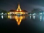
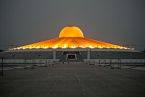
Clockwise from top left: Thailand National Memorial, A Royal Ploughing Ceremony exhibition in Golden Jubilee Museum of Agriculture, Tornado ride in the Dream World, Wat Phra Dhammakaya, National Science Museum, Thammasat University's pond. | |
| Motto(s): ถิ่นบัวหลวง เมืองรวงข้าว เชื้อชาวมอญ นครธรรมะ พระตำหนักรวมใจ สดใสเจ้าพระยา ก้าวหน้าอุตสาหกรรม ("Home of the royal lotus. Town of rice ears. Mon people. City of Dharma. Palace of unity. Bright Chao Phraya (River). Progressive industry.") | |
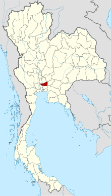
 Map of Thailand highlighting Pathum Thani province | |
| Country | Thailand |
| Region | Central Thailand |
| Capital | Pathum Thani |
| Largest City | Rangsit |
| Government | |
| • Governor | Vacant |
| Area | |
| • Total | 1,526 km2 (589 sq mi) |
| • Rank | Ranked 70th |
| Population (2019)[2] | |
| • Total | 1,163,604 |
| • Rank | Ranked 18th |
| • Density | 763/km2 (1,980/sq mi) |
| • Rank | Ranked 5th |
| Human Achievement Index | |
| • HAI (2022) | 0.6589 "somewhat high" Ranked 15th |
| GDP | |
| • Total | baht 381 billion (US$13 billion) (2019) |
| Time zone | UTC+7 (ICT) |
| Postal code | 10xxx |
| Calling code | 02 |
| ISO 3166 code | TH-13 |
| Website | pathumthani.go.th |
Pathum Thani (Thai: ปทุมธานี, pronounced [pā.tʰūm tʰāːnīː]) is one of the central provinces (changwat) of Thailand. Neighboring provinces are (from north clockwise): Phra Nakhon Si Ayutthaya, Saraburi, Nakhon Nayok, Chachoengsao, Bangkok, and Nonthaburi.
The province is north of Bangkok and is part of the Bangkok metropolitan area. In many places, the boundary between the two provinces is not noticeable as both sides of the boundary are equally urbanized. Pathum Thani town is the administrative seat, but Ban Rangsit, seat of Thanyaburi district, is the largest populated place in the province.[5]
Pathum Thani is an old province, heavily populated by the Mon people, dotted with 186 temples and parks. The Dream World amusement park is here.[citation needed]
- ^ Advancing Human Development through the ASEAN Community, Thailand Human Development Report 2014, table 0:Basic Data (PDF) (Report). United Nations Development Programme (UNDP) Thailand. pp. 134–135. ISBN 978-974-680-368-7. Retrieved 17 January 2016, Data has been supplied by Land Development Department, Ministry of Agriculture and Cooperatives, at Wayback Machine.
{{cite report}}: CS1 maint: postscript (link)[dead link] - ^ "สถิติทางการทะเบียน" [Registration statistics]. bora.dopa.go.th. Department of Provincial Administration (DOPA). December 2019. Retrieved 22 September 2020.
Download จำนวนประชากร ปี พ.ศ.2562 - Download population year 2019
- ^ "ข้อมูลสถิติดัชนีความก้าวหน้าของคน ปี 2565 (PDF)" [Human Achievement Index Databook year 2022 (PDF)]. Office of the National Economic and Social Development Council (NESDC) (in Thai). Retrieved 12 March 2024, page 42
{{cite web}}: CS1 maint: postscript (link) - ^ "Gross Regional and Provincial Product, 2019 Edition". <>. Office of the National Economic and Social Development Council (NESDC). July 2019. ISSN 1686-0799. Retrieved 22 January 2020.
- ^ "Population Statistics 2008". Department of Provincial Administration. Archived from the original on 2010-03-25. Retrieved 2010-06-28.
Pathum Thani town population 18,843; Rangsit town population 76,843
© MMXXIII Rich X Search. We shall prevail. All rights reserved. Rich X Search


