Back نهر پاتيرسون ARZ Patterson River (suba sa Ostralya) CEB Rio Patterson Portuguese Patterson River Swedish
| Patterson Carrum Creek[1] | |
|---|---|
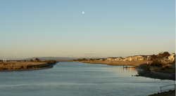 Patterson River, near Patterson Lakes | |
| Etymology | In honour of Sir James Patterson KCMG[2] |
| Location | |
| Country | Australia |
| State | Victoria |
| Region | South East Coastal Plain (IBRA), Greater Melbourne |
| Local government area | City of Kingston |
| Physical characteristics | |
| Source confluence | Dandenong Creek and Eumemmerring Creek |
| • location | southwest of Bangholme |
| • coordinates | 38°2′37″S 145°10′29″E / 38.04361°S 145.17472°E |
| • elevation | 6 m (20 ft) |
| Mouth | Beaumaris Bay, Port Phillip |
• location | at Carrum |
• coordinates | 38°4′26″S 145°7′6″E / 38.07389°S 145.11833°E |
• elevation | 0 m (0 ft) |
| Length | 5 km (3.1 mi) |
| Basin features | |
| River system | Port Phillip catchment |
| [1][3] | |

The Patterson River is a partly man-made urban river[2] of the Port Phillip catchment in the Australian east coast state of Victoria, located in the outer southeastern suburbs of the Greater Melbourne region. Under the name "Patterson", it is the shortest river in Victoria at only 5 km (3.1 mi) in length, although its main stem tributary and de facto upper section, the Dandenong Creek, is over 53 km (33 mi) long.
- ^ a b "Patterson River: 23275". Vicnames. Government of Victoria. 2 May 1966. Archived from the original on 13 April 2014. Retrieved 11 April 2014.
- ^ a b "Patterson River: 23275: Historical information". Vicnames. Government of Victoria. 5 February 1975. Archived from the original on 13 April 2014. Retrieved 11 April 2014.
- ^ "Map of Patterson River, VIC". Bonzle Digital Atlas of Australia. Retrieved 11 April 2014.
© MMXXIII Rich X Search. We shall prevail. All rights reserved. Rich X Search