Back مقاطعة باوني (أوكلاهوما) Arabic پاونی بؤلگهسی، اوکلاهوما AZB Pawnee County, Oklahoma BAR Поуни (окръг, Оклахома) Bulgarian পৱনি কাউন্টি, ওকলাহোমা BPY Pawnee Gông (Oklahoma) CDO Pawnee County (kondado sa Tinipong Bansa, Oklahoma) CEB Pawnee County, Oklahoma Welsh Pawnee County (Oklahoma) German Condado de Pawnee (Oklahoma) Spanish
Pawnee County | |
|---|---|
 Pawnee County Courthouse, 2014 | |
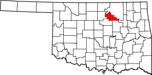
 Location within the U.S. state of Oklahoma | |
 Oklahoma's location within the U.S. | |
| Coordinates: 36°19′N 96°42′W / 36.31°N 96.7°W | |
| Country | |
| State | |
| Founded | 1893 |
| Named for | Pawnee Nation |
| Seat | Pawnee |
| Largest city | Cleveland |
| Area | |
| • Total | 595 sq mi (1,540 km2) |
| • Land | 568 sq mi (1,470 km2) |
| • Water | 27 sq mi (70 km2) 4.5% |
| Population (2020) | |
| • Total | 15,553 |
| • Density | 26/sq mi (10/km2) |
| Congressional district | 3rd |
| Website | www |
Pawnee County is a county located in the U.S. state of Oklahoma. As of the 2020 census, the population was 15,553.[1] Its county seat is Pawnee.[2] The county is named after the Pawnee Nation,[3] whose reservation used to encompass the county prior to allotment in 1893.
Pawnee County is included in the Tulsa, OK metropolitan statistical area.
- ^ "Pawnee County, Oklahoma". United States Census Bureau. Retrieved May 20, 2023.
- ^ "Find a County". National Association of Counties. Archived from the original on May 31, 2011. Retrieved June 7, 2011.
- ^ Wilson, Linda D. "Pawnee County," Encyclopedia of Oklahoma History and Culture, Oklahoma Historical Society, 2009. Accessed April 4, 2015.
© MMXXIII Rich X Search. We shall prevail. All rights reserved. Rich X Search