Back نهر پايت ARZ Payette River CEB Payette River German Río Payette Spanish Payette (joki) Finnish Payette (rivière) French Пейетт (река) Russian 佩埃特河 Chinese
| Payette River South Fork Payette River | |
|---|---|
 The lower course of the Payette River | |
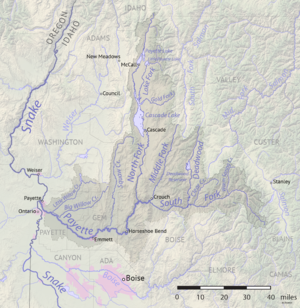
 Map of the Payette River watershed | |
| Location | |
| Country | United States |
| State | Idaho |
| Region | Payette County |
| City | Emmett |
| Physical characteristics | |
| Source | North Fork Payette River |
| • location | Deep Lake, Boise County |
| • coordinates | 45°10′47″N 115°59′37″W / 45.17972°N 115.99361°W |
| • elevation | 7,380 ft (2,250 m) |
| 2nd source | South Fork Payette River |
| • location | A small unnamed lake near Vernon Lake, Boise County |
| • coordinates | 43°57′51″N 115°00′02″W / 43.96417°N 115.00056°W |
| • elevation | 8,820 ft (2,690 m) |
| Source confluence | Near Banks |
| • location | Payette County |
| • coordinates | 44°05′04″N 116°06′54″W / 44.08444°N 116.11500°W |
| • elevation | 2,790 ft (850 m) |
| Mouth | Snake River |
• location | Payette, Payette County |
• coordinates | 44°05′32″N 116°57′09″W / 44.09222°N 116.95250°W |
• elevation | 2,125 ft (648 m) |
| Length | 83 mi (134 km), East-West |
| Basin size | 3,240 sq mi (8,400 km2) |
| Discharge | |
| • average | 2,803 cu ft/s (79.4 m3/s) |
| • maximum | 32,000 cu ft/s (910 m3/s) |
| Basin features | |
| River system | Snake River |
| Tributaries | |
| • left | South Fork Payette River |
| • right | North Fork Payette River, Big Willow Creek |
The Payette River (/peɪˈɛt/) is an 82.7-mile-long (133.1 km)[1] river in southwestern Idaho and is a major tributary of the Snake River.
Its headwaters originate in the Sawtooth and Salmon River Mountains at elevations over 10,000 feet (3,000 m). Drainage in the watershed flows primarily from east to west, with the cumulative stream length to the head of the North Fork Payette River being 180 miles (290 km),[1] while to the head of the South Fork the cumulative length is nearly 163 miles (262 km).[1] The combined Payette River flows into an agricultural valley and empties into the Snake River near the city of Payette at an elevation of 2,125 feet (648 m). The Payette River's drainage basin comprises about 3,240 square miles (8,400 km2).[2] It is a physiographic section of the Columbia Plateau province, which in turn is part of the larger Intermontane Plateaus physiographic division. The South Fork of the Payette has its headwaters in the Sawtooth Wilderness, which is part of the Sawtooth National Recreation Area.
- ^ a b c U.S. Geological Survey. National Hydrography Dataset high-resolution flowline data. The National Map, accessed May 3, 2011
- ^ "North Fork Payette River Subbasin Assessment" (PDF). Idaho Department of Environmental Quality. Archived from the original (PDF) on 2 October 2009. Retrieved 20 January 2010.
© MMXXIII Rich X Search. We shall prevail. All rights reserved. Rich X Search