| Pemigewasset Wilderness Area | |
|---|---|
 | |
| Location | Grafton County, New Hampshire, USA |
| Nearest city | Lincoln, New Hampshire |
| Coordinates | 44°06′45″N 71°31′36″W / 44.11250°N 71.52667°W |
| Area | 45,000 acres (182 km2) |
| Established | 1984 |
| Governing body | United States Forest Service |
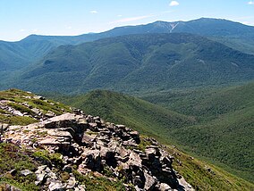
The Pemigewasset Wilderness is a 45,000-acre (182 km2) federally designated Wilderness Area in the heart of New Hampshire's White Mountains. It is a part of the White Mountain National Forest. It is New Hampshire's largest wilderness area.[1]
The Wilderness Area consists of the upper watershed of the East Branch of the Pemigewasset River, and includes the Franconia, Twin, Zealand, and Hancock mountain ranges, but excludes the summits of the ranges and the trail along them. As a result of the region's rugged character, the Pemigewasset Wilderness is a popular recreation area; its large trail network receives heavy use, in the form of hiking, cross-country skiing, and others, throughout the year.
The area is also noted for its ecological recovery from the logging era of the late nineteenth and early twentieth centuries. After years of unchecked clear-cutting, during which the zone had the largest logging railroad system in the White Mountains, the area's inclusion in the White Mountain National Forest and later designation as a Wilderness Area has led to a substantial rebound in the forest ecosystem.[2]
- ^ "Pemigewasset Wilderness". Smithsonian. Retrieved 2018-10-23.
- ^ "Alpha Guide: The Pemigewasset Loop | Hiking the Pemi Loop - goEast". goEast. 2017-07-07. Retrieved 2018-10-23.
© MMXXIII Rich X Search. We shall prevail. All rights reserved. Rich X Search

