Back نهر بيند أوريل Arabic نهر پيند اوريل ARZ پند اوریله چایی AZB Панд Орей (река) Bulgarian Pend-d'Oreille River CEB Pend Oreille River Danish Pend Oreille River German Río Pend Oreille Spanish Pend Oreille French Pend d'Oreille Italian
| Pend Oreille Pend-d'Oreille, Clark Fork | |
|---|---|
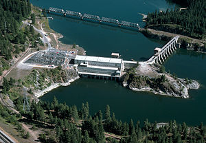
 Albeni Falls Dam on the Pend Oreille River | |
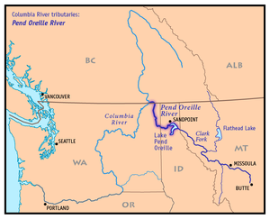
 Map of the Pend Oreille River and its main tributaries. | |
| Location | |
| Country | United States, Canada |
| State | Washington, Idaho |
| Province | British Columbia |
| City | Sandpoint, ID |
| Physical characteristics | |
| Source | Lake Pend Oreille |
| • location | Idaho |
| • coordinates | 48°14′20″N 116°36′25″W / 48.23889°N 116.60694°W |
| • elevation | 2,064 ft (629 m)[1] |
| Mouth | Columbia River |
• location | British Columbia |
• coordinates | 49°0′13″N 117°37′13″W / 49.00361°N 117.62028°W |
• elevation | 1,371 ft (418 m)[2] |
| Length | 130 mi (210 km)[3] |
| Basin size | 25,792 sq mi (66,800 km2)[4] |
| Discharge | |
| • location | below Box Canyon Dam, 34.3 miles (55.2 km) from the mouth[5] |
| • average | 26,320 cu ft/s (745 m3/s)[6] |
| • minimum | 82 cu ft/s (2.3 m3/s) |
| • maximum | 167,000 cu ft/s (4,700 m3/s) |
| Basin features | |
| Tributaries | |
| • right | Clark Fork, Pack River, Priest River, Salmo River |
The Pend Oreille River (/ˌpɒndəˈreɪ/ POND-ə-RAY) is a tributary of the Columbia River, approximately 130 miles (209 km) long, in northern Idaho and northeastern Washington in the United States, as well as southeastern British Columbia in Canada. In its passage through British Columbia its name is spelled Pend-d'Oreille River.[7] It drains a scenic area of the Rocky Mountains along the U.S.-Canada border on the east side of the Columbia. The river is sometimes defined as the lower part of the Clark Fork, which rises in western Montana. The river drains an area of 66,800 square kilometres (25,792 sq mi),[4] mostly through the Clark Fork and its tributaries in western Montana and including a portion of the Flathead River in southeastern British Columbia. The full drainage basin of the river and its tributaries accounts for 43% of the entire Columbia River Basin above the confluence with the Columbia.[8] The total area of the Pend Oreille basin is just under 10% of the entire 258,000-square-mile (670,000 km2) Columbia Basin. Box Canyon Dam is currently underway on a multimillion-dollar project for a fish ladder.
- ^ Google Earth elevation for GNIS source coordinates.
- ^ Google Earth elevation for mouth of Pend Oreille River.
- ^ Pend Oreille River Archived 2005-05-11 at the Wayback Machine, The Columbia Gazetteer of North America. 2000.
- ^ a b Seven Mile Project Water use Plan[permanent dead link], BC Hydro
- ^ "USGS Gage #12396500 on the Pend Oreille River below Box Canyon, near Ione, WA" (PDF). National Water Information System. U.S. Geological Survey. 1952–2013. Retrieved 2014-10-13.
- ^ "USGS Gage #12396500 on the Pend Oreille River below Box Canyon, near Ione, WA" (PDF). National Water Information System. U.S. Geological Survey. 1952–2013. Retrieved 2014-10-13.
- ^ "Pend-d'Oreille River". BC Geographical Names. Retrieved 2015-03-24.
- ^ Water Quality Assessment of Pend d'Oreille River at Waneta Archived 2011-06-05 at the Wayback Machine, Ministry of Environment, Canada
© MMXXIII Rich X Search. We shall prevail. All rights reserved. Rich X Search