Back حوض الخليج العربي Arabic İran körfəzi neft və qaz hövzəsi Azerbaijani حوضه خلیج فارس Persian Парсы шығанағы мұнайлы-газды алабы Kazakh Нефтегазоносный бассейн Персидского залива Russian Нафтогазоносний басейн Перської затоки Ukrainian Fors qoʻltigʻi neft-gaz havzasi Uzbek
| Persian Gulf Basin | |
|---|---|
| Stratigraphic range: Precambrian to Neogene | |
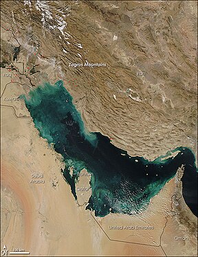
 Satellite picture of the Arabian Plate Basin | |
| Type | Foreland Basin |
| Area | 240,000 km2 (93,000 sq mi) |
| Thickness | 12 to 13 km [1] |
| Location | |
| Location | Iran, Iraq, Kuwait, Saudi Arabia, Qatar, Bahrain, United Arab Emirates and Oman (exclave of Musandam) |
| Region | Western Asia |
| Type section | |
| Country | Iran, Kuwait, United Arab Emirates, Saudi Arabia, Qatar, Oman, Bahrain and Iraq |
The Persian Gulf Basin (Persian: آبخیز خلیج فارس, Arabic: حوض الخليج العربي) is found between the Eurasian and the Arabian Plate. The Persian Gulf is described as a shallow marginal sea of the Indian Ocean that is located between the south western side of Zagros Mountains and the Arabian Peninsula and south and southeastern side of Oman and the United Arab Emirates. Other countries that border the Persian Gulf basin include; Saudi Arabia, Qatar, Kuwait, Bahrain and Iraq. The Persian Gulf extends a distance of 1,000 km (620 mi) with an area of 240,000 km2 (93,000 sq mi). The Arabian Plate basin a wedge-shaped foreland basin which lies beneath the western Zagros thrust and was created as a result of the collision between the Arabian and Eurasian plates.[2]
- ^ A. I. Konyuhov, B. Maleki, The Persian Gulf Basin: Geological history, sedimentary formations, and petroleum potential / Lithology and Mineral Resources. July 2006, Volume 41, Issue 4, pp 344–361 doi:10.1134/S0024490206040055
- ^ . A Brief Tectonic History of the Arabian basin. Retrieved from the website: http://www.sepmstrata.org/page.aspx?pageid=133
© MMXXIII Rich X Search. We shall prevail. All rights reserved. Rich X Search