Back Petaling CEB Distrik Petaling ID Distretto di Petaling Italian Petaling JV Petaling Malay Petaling (district) Dutch பெட்டாலிங் மாவட்டம் Tamil ضلع پیٹلنگ Urdu Petaling Vietnamese 八打灵县 Chinese
Petaling District | |
|---|---|
| Daerah Petaling | |
| Other transcription(s) | |
| • Jawi | ڤتاليڠ |
| • Chinese | 八打灵县 |
| • Tamil | பெட்டாலிங் |
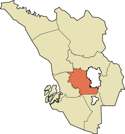
 Location of Petaling District in Selangor | |
 | |
Location of Petaling District in Malaysia | |
| Coordinates: 3°05′N 101°35′E / 3.083°N 101.583°E | |
| Country | |
| State | |
| Seat | Subang, Damansara, Shah Alam, Puchong, Kelana Jaya and Petaling Jaya |
| Local area government(s) | Petaling Jaya City Council (East) Shah Alam City Council (West) Subang Jaya City Council (South) |
| Government | |
| • District officer | Misri Idris[1] |
| • Sultan's Representative | Emran Kadir[2] |
| Area | |
| • Total | 484.32 km2 (187.00 sq mi) |
| Population (2020)[4] | |
| • Total | 2,298,123 |
| • Density | 4,700/km2 (12,000/sq mi) |
| Time zone | UTC+8 (MST) |
| • Summer (DST) | UTC+8 (Not observed) |
| Postcode | 40xxx, 43xxx, 46xxx, 47xxx |
| Calling code | +6-03-5, +6-03-6, +6-03-7, +6-03-8 |
| Vehicle registration plates | B |
The Petaling District is a district located in the heart of Selangor in Malaysia. Petaling is not to be confused with the city of Petaling Jaya located in it, nor the mukim of Petaling under Subang Jaya City. The district office is located in Subang.
The district of Petaling was established on 1 February 1974, the same day Kuala Lumpur was declared a Federal Territory. This district is located in the middle of the Klang Valley adjacent to the capital and thus has experienced tremendous urbanisation. Some of the original forests remain in the Bukit Cherakah Forest Reserve (including the National Botanic Gardens), Kota Damansara Community Forest Park and Bukit Gasing. During the 1991 census, it recorded 633,165 people.[citation needed]
The official 2010 census recorded the population of Petaling as 1,660,869 people, excluding foreigners.[4] Petaling is 484.32 km2 in area.[3] The urban centres are divided into the cities of Shah Alam, Petaling Jaya and Subang Jaya. However, there are numerous town subdivisions, old subdistrict administrations (mukim), all of which share the same names like Damansara, Subang, and Petaling, which add much to the administrative confusion along with the rapid growth. Some five types of subdivisions exist for Petaling District, namely the re-organized municipal council majlis, the majlis subdivisions, the community names (also known as townships), electoral constituencies, and the subdivisions ("mukim").
It is host to many thriving townships such as the Damansara area, which hosts several shopping malls including a Tesco and an IKEA outlet. Sultan Abdul Aziz Shah Airport is situated in Subang.
- ^ "Portal Rasmi PDT Petaling Senarai Pegawai Daerah Petaling". www2.selangor.gov.my.
- ^ "Portal Rasmi PDT Petaling Orang Besar Daerah". www2.selangor.gov.my.
- ^ a b "Portal Rasmi PDT Petaling Sejarah Daerah Petaling". www2.selangor.gov.my.
- ^ a b "Population Distribution and Basic Demographic Characteristics, 2010" (PDF). Department of Statistics, Malaysia. Archived from the original (PDF) on 22 May 2014. Retrieved 19 April 2012.
© MMXXIII Rich X Search. We shall prevail. All rights reserved. Rich X Search
