Back منطقة فراي ناخون Arabic Пхранакхон Bashkir খেত ফরা নাখোন BPY Khet Phra Nakhon CEB Phra Nakhon German Phra Nakhon Spanish Phra Nakhon Estonian Phra Nakhon French Phra Nakhon Italian プラナコーン区 Japanese
Phra Nakhon
พระนคร | |
|---|---|
 | |
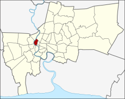
 District location in Bangkok | |
| Coordinates: 13°45′52″N 100°29′57″E / 13.76444°N 100.49917°E | |
| Country | Thailand |
| Province | Bangkok |
| Seat | Wat Sam Phraya |
| Khwaeng | 12 |
| Area | |
| • Total | 5.536 km2 (2.137 sq mi) |
| Population (2017) | |
| • Total | 51,231[1] |
| • Density | 9,254.15/km2 (23,968.1/sq mi) |
| Time zone | UTC+7 (ICT) |
| Postal code | 10200 |
| Geocode | 1001 |

Phra Nakhon (Thai: พระนคร, pronounced [pʰráʔ ná(ʔ).kʰɔ̄ːn]) is one of the 50 districts (khet) of Bangkok, Thailand. It is the central district of Bangkok, including Rattanakosin Island. Neighboring districts are, from the north, clockwise: Dusit, Pom Prap Sattru Phai, Samphanthawong, and across the Chao Phraya River, Thon Buri, Bangkok Yai, Bangkok Noi, and Bang Phlat.
- ^ "Population and House Report for Year 2017". Department of Provincial Administration, Ministry of Internal Affairs. Retrieved 2018-04-01. (Search page)
© MMXXIII Rich X Search. We shall prevail. All rights reserved. Rich X Search
