Back Fyzická geografie Spojených států amerických Czech Regiones fisiográficas de los Estados Unidos Spanish Regiony fizjograficzne Stanów Zjednoczonych Polish


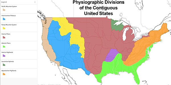
The physiographic regions of the contiguous United States comprise 8 divisions, 25 provinces, and 85 sections.[1] The system dates to Nevin Fenneman's report Physiographic Divisions of the United States, published in 1916.[2] [3] The map was updated and republished by the Association of American Geographers in 1928.[4] The map was adopted by the United States Geological Survey by publication in 1946. [5]
The classification hierarchy used in the 1916 publication of the American Association of Geographers was division/province/section/subsection. The use of province in this hierarchy undoubtedly confounded the effort to develop a physiographical map consistent across the North American continent since Canada used province as the term for its first-level political subdivision. Province in Canada is a loose analogy for state in the US, and obviously would create great confusion if the same word was used in two vastly different geographical classifications. As late as 1914, the terminology used by an AAG publication used the term "natural region" as the basic denomination of physiography. [6] That work showed 22 examples of how geographers had published works classifying North America into what had been defined as natural regions. Most included all of North America without regard to political subdivision.
Fenneman expanded and presented a derivative of this system more fully in two books, Physiography of western United States (1931),[7] and Physiography of eastern United States (1938).[8]
- ^ "Physiographic Regions". United States Geological Survey. 2003-04-17. Archived from the original on 2006-05-15. Retrieved 2008-01-30.
- ^ Fenneman, Nevin M. (1916). "Physiographic Divisions of the United States". Annals of the Association of American Geographers. 6 (1): 19–98. doi:10.1080/00045601609357047. hdl:2027/njp.32101059544153. ISSN 0004-5608.
- ^ Fenneman, Nevin M. (1917). "Physiographic Subdivision of the United States". Proceedings of the National Academy of Sciences of the United States of America. 3 (1): 17–22. doi:10.1073/pnas.3.1.17. OCLC 43473694. PMC 1091163. PMID 16586678.
- ^ Fenneman, Nevin M. (1928). "Physiographic Divisions of the United States". Annals of the Association of American Geographers. 18 (4): 261–353. doi:10.2307/2560726. hdl:2027/njp.32101059544153. JSTOR 2560726.
- ^ Fenneman, Nevin M. (1946). Physical divisions of the United States (Report). U.S. Geological Survey. doi:10.3133/70207506.
- ^ Joerg, Wolfgang L. G. (1914). "The Subdivision of North America into Natural Regions: A Preliminary Inquiry". Annals of the Association of American Geographers. 4: 55–83. doi:10.2307/2560741. JSTOR 2560741.
- ^ Fenneman, Nevin Melancthon (1931). Physiography of western United States. McGraw-Hill. OCLC 487636.
- ^ Fenneman, Nevin Melancthon (1938). Physiography of eastern United States. McGraw-Hill. OCLC 487628.
© MMXXIII Rich X Search. We shall prevail. All rights reserved. Rich X Search