Back Río Piedra AN نهر پيدرا ARZ Riu Piedra Catalan Río Piedra (suba sa Espanya) CEB Piedra (rivero) Esperanto Río Piedra Spanish Piedra (rivière) French Пьедра (приток Халона) Russian Río Piedra (vattendrag i Spanien) Swedish 彼德拉河 Chinese
| Piedra | |
|---|---|
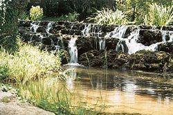
 The Piedra flowing through the Monasterio de Piedra area | |
 The watershed of the Piedra within the Ebro basin. | |
| Native name | Río Piedra (Spanish) |
| Location | |
| Country | Spain |
| Region | Castile-La Mancha, Aragón |
| District | province of Guadalajara, province of Zaragoza |
| City | Campillo de Dueñas, Cimballa, Nuévalos, Carenas, Castejón de las Armas |
| Physical characteristics | |
| Source | Campillo de Dueñas |
| • location | province of Guadalajara, Castile-La Mancha, Spain |
| • coordinates | 40°49′59″N 1°39′18″W / 40.833°N 1.655°W |
| • elevation | 1,195 m (3,921 ft) |
| Mouth | Castejón de las Armas |
• location | province of Zaragoza, Aragón, Spain |
• coordinates | 41°19′08″N 1°48′36″W / 41.319°N 1.810°W |
• elevation | 590 m (1,940 ft) |
| Length | 76 km (47 mi) |
| Discharge | |
| • average | 1.22 m3/s (43 cu ft/s) |
| Basin features | |
| Progression | Jalón→ Ebro→ Balearic Sea |
| Tributaries | |
| • left | Mesa River |
| • right | Ortiz, Munebraga |
| River system | Ebro |
The Piedra (Spanish: Río Piedra) is a river in the Iberian System area, Spain. It is a tributary of the river Jalón. The waters have a high concentration of calcium carbonate[1] which is deposited on plant life near the source, giving the river its name Río Piedra, which means 'stone river' in English.
The population of the endangered European freshwater crayfish in the river and its tributaries has practically disappeared owing to the introduction of the North American signal crayfish (Pacifastacus leniusculus).[2]
- ^ Cite error: The named reference
ijes-may-2009was invoked but never defined (see the help page). - ^ Río Piedra, Entorno Natural en la Provincia de Zaragoza
© MMXXIII Rich X Search. We shall prevail. All rights reserved. Rich X Search