Back بيرفيل (كيبك) Arabic پیرویل، کوبک AZB Pierreville (munisipyo) CEB Pierreville (Quebec) Basque پیرویل، کبک Persian Pierreville (Québec) French Pierreville (Québec) Italian Пьервиль (Квебек) Russian Pierreville, Québec Swedish 皮埃尔维尔 Chinese
Pierreville | |
|---|---|
 | |
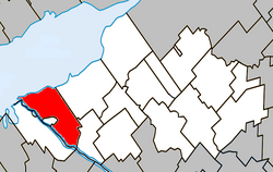
 Location within Nicolet-Yamaska RCM | |
| Coordinates: 46°04′N 72°49′W / 46.067°N 72.817°W[1] | |
| Country | |
| Province | |
| Region | Centre-du-Québec |
| RCM | Nicolet-Yamaska |
| Constituted | June 13, 2001 |
| Government | |
| • Mayor | André Descôteaux |
| • Federal riding | Bécancour—Nicolet—Saurel |
| • Prov. riding | Nicolet-Bécancour |
| Area | |
| • Total | 124.90 km2 (48.22 sq mi) |
| • Land | 78.31 km2 (30.24 sq mi) |
| Population | |
| • Total | 2,176 |
| • Density | 27.8/km2 (72/sq mi) |
| • Pop 2006–2011 | |
| • Dwellings | 1,152 |
| Time zone | UTC−5 (EST) |
| • Summer (DST) | UTC−4 (EDT) |
| Postal code(s) | |
| Area code(s) | 450 and 579 |
| Highways | |
| Website | www |
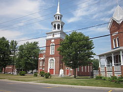
Pierreville (French pronunciation: [pjɛʁvil] ) is a municipality in Nicolet-Yamaska Regional County Municipality, Quebec, located at the confluence of the Saint Lawrence and Saint-François rivers, at the edge of Lac Saint-Pierre. The population as of the Canada 2011 Census was 2,176.
Pierreville faces the town of Saint-François-du-Lac across the Saint-François river, and lies at the junction of Route 132 and Route 226. Part of the Abenaki Indian reserve of Odanak is an enclave within the city limits of Pierreville. The limits of the reserve begin only a short walk away from the town's main street.
- ^ Cite error: The named reference
toponymiewas invoked but never defined (see the help page). - ^ a b "Pierreville - Répertoire des municipalités - Ministère des Affaires municipales et de l'Occupation du territoire". mamrot.gouv.qc.ca. Retrieved 2015-02-20.
- ^ "Parliament of Canada Federal Riding History: BAS-RICHELIEU--NICOLET--BÉCANCOUR (Quebec)". www2.parl.gc.ca. Archived from the original on 2009-06-09. Retrieved 2015-02-20.
- ^ a b "2011 Statistics Canada Census Profile: Pierreville, Quebec". www12.statcan.gc.ca. Retrieved 2015-02-20.
© MMXXIII Rich X Search. We shall prevail. All rights reserved. Rich X Search
