Back پاین پلینز ، نیویورک AZB Pine Plains Catalan Пайн-Плейнс (бахархой лерина меттиг, Нью-Йорк) CE Pine Plains (condado de Dutchess) Spanish پاین پلینز (حوزه سرشماری)، نیویورک Persian Pine Plains (CDP, New York) French Pine Plains (CDP), New York Malagasy Pine Plains (hrabstwo Dutchess) Polish Pine Plains (CDP), New York SIMPLE Пайн-Плейнс (сан алу урыны, Нью-Йорк) Tatar
Pine Plains, New York | |
|---|---|
 Pine Plains from the fire tower on Stissing Mountain to the southeast | |
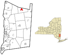
 Location of Pine Plains, New York | |
| Coordinates: 41°58′44″N 73°39′41″W / 41.97889°N 73.66139°W | |
| Country | United States |
| State | New York |
| County | Dutchess |
| Town | Pine Plains |
| Area | |
| • Total | 2.30 sq mi (5.96 km2) |
| • Land | 2.08 sq mi (5.39 km2) |
| • Water | 0.22 sq mi (0.57 km2) |
| Elevation | 469 ft (143 m) |
| Population (2020) | |
| • Total | 1,142 |
| • Density | 549.04/sq mi (211.94/km2) |
| Time zone | UTC-5 (EST) |
| • Summer (DST) | UTC-4 (EDT) |
| ZIP code | 12567 |
| Area code | 518 |
| FIPS code | 36-58145 |
| GNIS feature ID | 0960532 |
Pine Plains is a hamlet and census-designated place (CDP) in Dutchess County, New York, United States. The population was 1,142 at the 2020 census.[2] It is part of the Poughkeepsie–Newburgh–Middletown, NY Metropolitan Statistical Area as well as the larger New York–Newark–Bridgeport, NY-NJ-CT-PA Combined Statistical Area.
The community of Pine Plains is in the town of Pine Plains.
- ^ "ArcGIS REST Services Directory". United States Census Bureau. Retrieved September 20, 2022.
- ^ a b "2020 Census Redistricting Data: Pine Plains CDP, New York". data.census.gov. U.S. Census Bureau. Retrieved February 10, 2023.
© MMXXIII Rich X Search. We shall prevail. All rights reserved. Rich X Search