Back بينيفيلي (لويزيانا) Arabic بينيفيلى (لويزيانا) ARZ پاینویل، لوئیزیانا AZB Pineville (Louisiana) Catalan Пайнвилл (Луизиана) CE Pineville (lungsod sa Tinipong Bansa, Louisiana) CEB Pineville, Louisiana Welsh Pineville (Louisiana) German Pineville (Luisiana) Spanish Pineville (Louisiana) Basque
Pineville, Louisiana | |
|---|---|
| City of Pineville | |
 | |
 Location of Pineville in Rapides Parish, Louisiana. | |
 Location of Louisiana in the United States | |
| Coordinates: 31°20′20″N 92°24′45″W / 31.33889°N 92.41250°W | |
| Country | United States |
| State | Louisiana |
| Parish | Rapides |
| Government | |
| • Mayor | Rich Dupree (R) |
| Area | |
| • Total | 13.14 sq mi (34.04 km2) |
| • Land | 12.62 sq mi (32.68 km2) |
| • Water | 0.52 sq mi (1.36 km2) |
| Elevation | 118 ft (36 m) |
| Population (2020) | |
| • Total | 14,384 |
| • Rank | RA: 2nd |
| • Density | 1,139.96/sq mi (440.15/km2) |
| Time zone | UTC-6 (CST) |
| • Summer (DST) | UTC-5 (CDT) |
| ZIP code | 71360[2] |
| FIPS code | 22-60530 |
| Website | www.pineville.net |
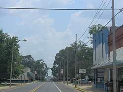
Pineville is a city in Rapides Parish, Louisiana, United States. It is located across the Red River from the larger Alexandria, and is part of the Alexandria Metropolitan Statistical Area. The population was 14,555 at the 2010 census. It had been 13,829 in 2000; population hence grew by 5 percent over the preceding decade.[3]
The Central Louisiana State Hospital, the Pinecrest Supports and Services Center, the Huey P. Long Memorial Hospital (closed), the Alexandria Veterans Administration Medical Center, and the Alexandria National Cemetery are all located in Pineville. The city is also home to several large non-government employers including Baker Manufacturing, Procter & Gamble, and Crest Industries.
- ^ "2020 U.S. Gazetteer Files". United States Census Bureau. Retrieved March 20, 2022.
- ^ "Pineville LA ZIP Code". zipdatamaps.com. 2023. Retrieved January 26, 2023.
- ^ "2010 Census". quickfacts.census.gov. Archived from the original on January 7, 2012. Retrieved April 27, 2012.
© MMXXIII Rich X Search. We shall prevail. All rights reserved. Rich X Search