Back Pingo National Landmark Danish Pingo Canadian Landmark German Hito nacional Pingo Spanish Site canadien des Pingos French Пинго (национальная достопримечательность) Russian Pingo National Landmark Swedish 冰核丘国家地标 Chinese
| Pingo National Landmark | |
|---|---|
IUCN category VI (protected area with sustainable use of natural resources)[1] | |
 | |
Location of Pingo National Landmark in Canada Location of Pingo Canadian Landmark in Northwest Territories | |
| Location | Northwest Territories, Canada |
| Nearest city | Tuktoyaktuk, NT |
| Coordinates | 69°23′59″N 133°04′47″W / 69.39972°N 133.07972°W |
| Area | 16 km2 (6.2 sq mi) |
| Established | 25 July 1984 |
| Governing body | Parks Canada |
| www | |
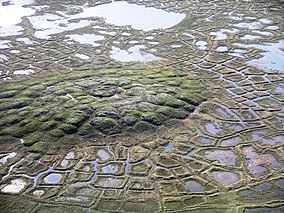
Pingo Canadian Landmark, also known as Pingo National Landmark, is a natural area protecting eight pingos near Tuktoyaktuk, Northwest Territories. It is in a coastal region of the Arctic Ocean which contains approximately 1,350 Arctic ice dome hills—approximately one quarter of the world's pingos.[2]
- ^ "Protected Planet | Pingo Canadian Landmark". Protected Planet. Retrieved 2020-10-13.
- ^ Parks Canada (2005). "Pingo Canadian Landmark". Archived from the original on 2007-06-03. Retrieved 2008-01-05.
© MMXXIII Rich X Search. We shall prevail. All rights reserved. Rich X Search

