Back Pisgah National Forest CEB Pisgah National Forest Danish Pisgah National Forest German جنگل ملی پیزگاه Persian Forêt nationale de Pisgah French Foresta nazionale di Pisgah Italian പിസ്ഗാ ദേശീയ വനം Malayalam 皮斯加国家森林 Chinese
| Pisgah National Forest | |
|---|---|
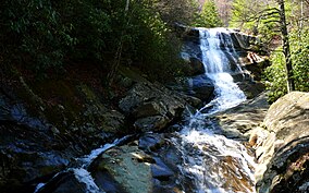
 Upper Creek Falls near the community of Linville in Pisgah National Forest | |
| Location | North Carolina, United States |
| Nearest city | Asheville, NC |
| Coordinates | 35°21′36″N 82°47′35″W / 35.36°N 82.793°W |
| Area | 512,758 acres (2,075.06 km2)[1] |
| Established | October 17, 1916[2] |
| Governing body | U.S. Forest Service |
| Website | Pisgah National Forest |
Pisgah National Forest is a National Forest in the Appalachian Mountains of western North Carolina. It is administered by the United States Forest Service, part of the United States Department of Agriculture. The Pisgah National Forest is completely contained within the state of North Carolina. The forest is managed together with the other three North Carolina National Forests (Croatan, Nantahala, and Uwharrie) from common headquarters in Asheville, North Carolina. There are local ranger district offices located in Pisgah Forest, Mars Hill, and Nebo.
- ^ "Land Areas of the National Forest System" (PDF). U.S. Forest Service. January 2012. Retrieved June 26, 2012.
- ^ "The National Forests of the United States" (PDF). ForestHistory.org. Retrieved July 26, 2012.
© MMXXIII Rich X Search. We shall prevail. All rights reserved. Rich X Search
