Back قاعدة ثول الجوية Arabic Base aérea de Thule AST Авіябаза Туле Byelorussian Тулэ (авіябаза) BE-X-OLD Thule Air Base CEB Pituffik Space Base Danish Pituffik Space Base German Aerbazo Thule Esperanto Base aérea de Thule Spanish پایگاه فضایی پیتوفیک Persian
| Pituffik Space Base | |||||||
|---|---|---|---|---|---|---|---|
| Near Qaanaaq, Avannaata in Greenland | |||||||
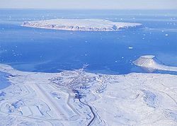
 Aerial view of Pituffik Space Base with Saunders Island in the background and the tombolo on the right | |||||||
 Shield of Space Base Delta 1 | |||||||
| Coordinates | 76°31′52″N 68°42′11″W / 76.53111°N 68.70306°W | ||||||
| Type | US Space Force base | ||||||
| Site information | |||||||
| Operator | United States Space Force | ||||||
| Controlled by | Space Base Delta 1 | ||||||
| Condition | Operational | ||||||
| Site history | |||||||
| Built | 1943 | ||||||
| In use | 1943–present | ||||||
| Events | B-52 crash (1968) | ||||||
| Garrison information | |||||||
| Garrison | 821st Space Base Group | ||||||
| Airfield information | |||||||
| Identifiers | IATA: THU, ICAO: BGTL, WMO: 042020 | ||||||
| Elevation | 76.5 metres (251 ft) AMSL | ||||||
| |||||||
| Source: Danish AIS[1] | |||||||

Pituffik Space Base (/biːduːˈfiːk/ bee-doo-FEEK;[2] Greenlandic: [pitufːik]) (IATA: THU, ICAO: BGTL), formerly Thule Air Base (/tuːliː/ or /tuːleɪ/), is the United States Space Force's northernmost base, and the northernmost installation of the U.S. Armed Forces, located 750 mi (1,210 km) north of the Arctic Circle and 947 mi (1,524 km) from the North Pole on the northwest coast of the island of Greenland. Pituffik's Arctic environment includes icebergs in North Star Bay, two islands (Saunders Island and Wolstenholme Island), a polar ice sheet, and Wolstenholme Fjord – the only place on Earth where four active glaciers join. The base is home to a substantial portion of the global network of missile warning sensors of Space Delta 4, and space surveillance and space control sensors of Space Delta 2, providing space awareness and advanced missile detection capabilities to North American Aerospace Defense Command (NORAD), the United States Space Force, and joint partners.
Pituffik Space Base is also home to the 821st Space Base Group and is responsible for space base support within the Pituffik Defense Area for the multinational population of "Team Pituffik". The base hosts the 12th Space Warning Squadron (12 SWS) which operates a Ballistic Missile Early Warning System (BMEWS) designed to detect and track ICBMs launched against North America. The base is also host to Detachment 1 of the 23rd Space Operations Squadron, part of the Space Delta 6's global satellite control network. The airfield's 10,000-foot (3,000 m) runway handles more than 3,000 US and international flights per year. The base is also home to the northernmost deep water port in the world.[3]
Pituffik Space Base has served as the regional hub for nearby installations, including Cape Atholl (LORAN station), Camp Century (Ice Cap Camp), Camp TUTO (Ice Cap Approach Ramp and Airstrip), Sites 1 and 2 (Ice Cap Radar Stations), P-Mountain (radar and communications site), J-Site (BMEWS), North and South Mountains (research sites), and a research rocket firing site.[not verified in body] It also was essential in the construction and resupply of High Arctic weather stations, including CFS Alert (Alert Airport) and Station Nord.
- ^ Greenland AIP for BGTL – Thule Air Base Archived 31 October 2020 at the Wayback Machine from Naviair
- ^ Cite error: The named reference
sn-20230406was invoked but never defined (see the help page). - ^ "821st Air Base Group". Peterson Air Force Base. Retrieved 7 November 2017.
© MMXXIII Rich X Search. We shall prevail. All rights reserved. Rich X Search
