Back بليسرفيل Arabic بليسرفيل ARZ پلئیسرویل، کالیفورنیا AZB Пласервіл Byelorussian Плейсървил (град, Калифорния) Bulgarian Placerville (Califòrnia) Catalan Плейсервилл (Калифорни) CE Placerville CEB Placerville German Placerville Esperanto
Placerville, California | |
|---|---|
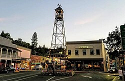
 Bell Tower on Main Street | |
| Nickname: Hangtown[1] | |
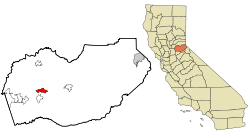
 Location of Placerville in California | |
| Coordinates: 38°43′47″N 120°47′55″W / 38.72972°N 120.79861°W[2] | |
| Country | |
| State | |
| County | El Dorado |
| Incorporated | May 13, 1854[3] |
| Government | |
| • Mayor | Kara Taylor[4] |
| Area | |
| • Total | 5.84 sq mi (15.13 km2) |
| • Land | 5.84 sq mi (15.13 km2) |
| • Water | 0.00 sq mi (0.00 km2) 0.01% |
| Elevation | 1,867 ft (569 m) |
| Population (2020) | |
| • Total | 10,747 |
| • Estimate (2019)[6] | 11,175 |
| • Density | 1,913.53/sq mi (738.79/km2) |
| Time zone | UTC-8 (PST) |
| • Summer (DST) | UTC-7 (PDT) |
| ZIP Code | 95667[7] |
| Area code | 530 |
| FIPS code | 06-57540 |
| GNIS feature IDs | 277577, 2411433 |
| Website | www |
| Official name | Placerville - Overland Pony Express Route[8] |
| Reference no. | 701 |
| Official name | Old Dry Higgins-Old Hangtown[9] |
| Reference no. | 475 |
Placerville (/ˈplæsərvɪl/, PLASS-ər-vil; formerly Old Dry Diggings, Dry Diggings, and Hangtown)[10][11] is a city in and the county seat of El Dorado County, California. The population was 10,747 as of the 2020 census, up from 10,389 as of the 2010 census. It is part of the Sacramento–Arden-Arcade–Roseville Metropolitan Statistical Area.
- ^ a b "Placerville". Geographic Names Information System. United States Geological Survey, United States Department of the Interior.
- ^ "US Gazetteer files: 2010, 2000, and 1990". United States Census Bureau. February 12, 2011. Retrieved April 23, 2011.
- ^ "California Cities by Incorporation Date". California Association of Local Agency Formation Commissions. Archived from the original (Word) on November 3, 2014. Retrieved April 5, 2013.
- ^ "Mayor Taylor". City of Placerville, CA. Archived from the original on January 23, 2022. Retrieved January 23, 2022.
- ^ "2019 U.S. Gazetteer Files". United States Census Bureau. Retrieved July 1, 2020.
- ^ Cite error: The named reference
USCensusEst2019CenPopScriptOnlyDirtyFixDoNotUsewas invoked but never defined (see the help page). - ^ "ZIP Code(tm) Lookup". United States Postal Service. Retrieved November 23, 2014.
- ^ "Placerville - Overland Pony Express RouteHangtown #701". Office of Historic Preservation, California State Parks. Retrieved October 7, 2012.
- ^ "Old Dry Higgins-Old Hangtown #475". Office of Historic Preservation, California State Parks. Retrieved October 7, 2012.
- ^ Durham, David L. (1998). California's Geographic Names: A Gazetteer of Historic and Modern Names of the State. Clovis, Calif.: Word Dancer Press. p. 539. ISBN 1-884995-14-4.
- ^ Svoboda, Dylan (June 5, 2021). "The NorCal town proud of its lynching history, until it wasn't". SFGATE. Retrieved June 8, 2021.
© MMXXIII Rich X Search. We shall prevail. All rights reserved. Rich X Search


