Playa | |
|---|---|
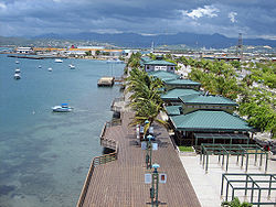
 La Guancha Boardwalk, one of the landmarks in Barrio Playa | |
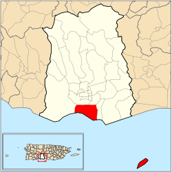
 Location of barrio Playa within the municipality of Ponce shown in red | |
| Coordinates: 17°58′13″N 66°36′16″W / 17.970406°N 66.604442°W[1] | |
| Commonwealth | |
| Municipality | |
| Area | |
| • Total | 14.99 sq mi (38.8 km2) |
| • Land | 4.39 sq mi (11.4 km2) |
| • Water | 10.60 sq mi (27.5 km2) |
| Elevation | 0 ft (0 m) |
| Population (2010) | |
| • Total | 14,077 |
| • Density | 3,206.6/sq mi (1,238.1/km2) |
| Source: 2010 Census | |
| Time zone | UTC−4 (AST) |
Barrio Playa, also known as Playa de Ponce, Ponce Playa, or La Playa, is one of the thirty-one barrios that comprise the municipality of Ponce, Puerto Rico. Along with Bucaná, Canas, Vayas, and Capitanejo, Playa is one of the municipality's five coastal barrios. Barrio Playa also incorporates several islands, the largest of which is Caja de Muertos.[3] It was founded in 1831.[4]
- ^ a b "US Gazetteer 2019". US Census. US Government.
- ^ U.S. Geological Survey Geographic Names Information System: Playa barrio
- ^ Map of Ponce Municipio, Puerto Rico. United States Geological Survey. Home Town Locator. Retrieved 6 June 2011.
- ^ Barrios de Ponce. Archived 30 September 2015 at the Wayback Machine Antepasados Esclavos.(From: Pedro Tomás de Córdoba. Memorias geográficas, históricas, económicas y estadísticas de la Isla de Puerto Rico.) Retrieved 28 November 2014.
© MMXXIII Rich X Search. We shall prevail. All rights reserved. Rich X Search
