Back مقاطعة بليموث (آيوا) Arabic Plymouth County, Iowa BAR Плимът (окръг, Айова) Bulgarian প্লাইমাউথ কাউন্টি, আইৱা BPY Plymouth Gông (Iowa) CDO Плимут (гуо, Айова) CE Plymouth County (kondado sa Tinipong Bansa, Iowa) CEB Plymouth County, Iowa Welsh Plymouth County (Iowa) German Kantono Plymouth (Iovao) Esperanto
42°44′18″N 96°13′13″W / 42.73833°N 96.22028°W
Plymouth County | |
|---|---|
 | |
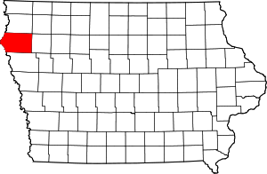
 Location within the U.S. state of Iowa | |
 Iowa's location within the U.S. | |
| Coordinates: 42°44′18″N 96°13′13″W / 42.738333333333°N 96.220277777778°W | |
| Country | |
| State | |
| Founded | January 15, 1851 |
| Named for | Plymouth, Massachusetts |
| Seat | Le Mars |
| Largest city | Le Mars |
| Area | |
| • Total | 864 sq mi (2,240 km2) |
| • Land | 863 sq mi (2,240 km2) |
| • Water | 0.8 sq mi (2 km2) 0.1% |
| Population (2020) | |
| • Total | 25,698 |
| • Density | 30/sq mi (11/km2) |
| Time zone | UTC−6 (Central) |
| • Summer (DST) | UTC−5 (CDT) |
| Congressional district | 4th |
| Website | www |
Plymouth County is a county located in the U.S. state of Iowa. As of the 2020 census, the population was 25,698.[1] The county seat is Le Mars.[2] Plymouth County was named after Plymouth, Massachusetts.[3]
Plymouth County is part of the Sioux City, IA-NE-SD Metropolitan Statistical Area.
- ^ "2020 Census State Redistricting Data". census.gov. United states Census Bureau. Retrieved August 12, 2021.
- ^ "Find a County". National Association of Counties. Retrieved June 7, 2011.
- ^ Chicago and North Western Railway Company (1908). A History of the Origin of the Place Names Connected with the Chicago & North Western and Chicago, St. Paul, Minneapolis & Omaha Railways. p. 163.
© MMXXIII Rich X Search. We shall prevail. All rights reserved. Rich X Search