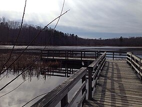
| Pocahontas State Park, Virginia, USA | |
|---|---|
 Lake at Pocahontas State Park in Virginia | |
| Location | 10301 State Park Rd., Chesterfield, VA 23832 |
| Coordinates | 37°22′29.3022″N 77°34′18.4146″W / 37.374806167°N 77.571781833°W |
| Area | 7,919 acres (3,205 ha) |
| Established | 1946 |
| Governing body | Virginia Department of Conservation and Recreation |
Pocahontas State Park is a state park located in Chesterfield, Virginia, United States, not far from the state capitol of Richmond. The park was laid out by the Civilian Conservation Corps along the Swift Creek, and at 7,919 acres (32.05 km2) is Virginia's largest state park.[1] In 2015, the park welcomed 1,142,601 visitors.[2]
The park is named after Chief Powhatan's daughter Pocahontas.
- ^ "Pocahontas State Park: Other info". Virginia Department of Conservation and Recreation. Retrieved March 27, 2017.
- ^ "POCAHONTAS STATE PARK" (PDF). Virginia Department of Conservation and Recreation. November 21, 2017. p. 6. Retrieved January 22, 2022.
© MMXXIII Rich X Search. We shall prevail. All rights reserved. Rich X Search


